|
||

|

|
|

|
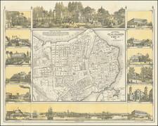
Striking, Rare Map of the Outskirts of Havana, Cuba
Rare map of the areas adjacent to Havana, Cuba and published in Havana in 1841. It was prepared for Rafael Rodríguez's important, unfinished Atlas Cubano.
The map is identified as "Plancha 3a. Parte 3a," part of a very rare set of sixteen or seventeen maps and plans of Cuba entitled Atlas Cubano. Consta de ocho hojas en papel marquilla apaisado, y contienen lo siguiente (1841-42).
East-oriented, the map shows the expansion of Havana, with an emphasis on the neighborhoods of San Lazaro, Guadalupe, and Jesus Maria. The rapid development of San Lazaro in particular is explained in a note to the right; the previous jumble of buildings had recently been replaced by orderly streets and new workshops and businesses.
Notable features include the arsenal, the railroad depot, and several defensive forts. The city gives way to a more rural aesthetic with country houses. To the east are the Botanical Garden and the formidable Castillo del Principe.
The coats of arms of Havana (left) and of the dedicatee, Claudio José Bernabé Alejandro Martinez de Pinillos y Ugarte, are prominently displayed. The latter was the son of the Count of Villanueva and was styled Viscount of Valvanera.
Emilio Cueto remarks that Rodríguez is one of three outstanding mapmakers of nineteenth-century Havana, alongside Albear and Pichardo. Rodríguez is the earliest of the three and his maps are integral to the history of Havana cartography.
The following is Emilio Cueto's complete entry describing the atlas:
528. Rodríguez Rodríguez [sic.], Rafael Ρίο (Spanish military surveyor, active ca. 1840s-1870s)
Rodriguez published the first Cuban atlas to be printed in Cuba (the Atlas Cubano), being a collection of 16 (?) city maps. Trelles mentions 17 maps, without listing them, and indeed the San Antonio map bears that number, but there are gaps in sequencing, so they do not add up to 17 in my count. Ads appearing in the Diario de La Habana for 1842 give different numbering altogether and could not confirm the existence of 17 maps . . . Maps measure ca. 19.75 X 15.25" and were lithographed at the Real Sociedad Patriótica in Havana during 1841-1842. I am unaware of the circumstances surrounding the conception and production of this important work. Copy in Havana National Library.
The atlas remained unfinished. Trelles cites a contemporary source indicating that "El geógrafo y ayudante del Cuerpo de Artillería Sr. Rodríguez no Ilegó a completar este Atlas." This is obvious, as there are only two maps east of Trinidad and no maps of Santiago or of the entire island. This might be the result not of purposeful design (the title appears all inclusive), but of lack of resources to complete the project. Such was the fate of an important book of Cuban views by Costa during 1841-1842. Similarly, some of Pichardo's efforts were limited to the western half of Cuba for lack of funds.
Rarity
The Atlas Cubano is exceedingly rare. We note only the copies in the Jose Martí Library in Havana, the University of Florida, and Harvard University.
Only a single incomplete copy has appeared at auction (Sothebys, 1988).
Rodriguez was a Cuban cartographer active between 1840 and 1870. He made maps alongside work as a soldier and surveyor. Rodriguez was an assistant to the artillery corps, gaining the rank of captain of the artillery. After completing topographical maps of the island he took a position with the government's stasitical commission in 1844. He is best known for his rare, incomplete Atlas Cubano (1841), one of the earliest atlases of Cuba.
![(Cuba - Includes Havana Harbor) Paskaert vande Noord Cust van Cuba Streckende van Bahia de Matancas to Bahia Honda. Beschreven door Roggeveen . . . [Chart of the North Coast of Cuba, Stretching from Matanzas Bay to Honda Bay. Described by Roggeveen...]](https://storage.googleapis.com/raremaps/img/small/63760.jpg)