|
||

|

|
|

|
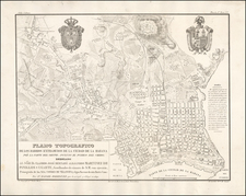
Rare map of Asuncion de Guanabacoa (unknown to Cueto), on the opposite side of the port of Havana, published by Rafael Rodriguez in Havana in 1856.
Cueto notes that "in addition to drafting numerous manuscripts plans and having the maps in the Planos de Bolsillo attributed to him by the Havana National Library, Cariés Casadeval at least" 3 other separately published maps.
The entry for the map in the University of Florida collection notes;
There are other impressions of this map with slight differences in the engravings.
It shows the views and plants of charitable buildings, heraldic shields and lines of the Matanzas railway with the branch that leads to Guanabacoa.
- Plant of the market square of Guanabacoa.
- Plant of the Hospital of Charity of Guanabacoa.
- View of the Church of Eusebio Romero.
- View of the Church of Potosí.
- View of the Market Square.
- View of the baths and fountain of Santa Rita.
- View of the Circus of the Sunset
- View of the convent of Santo Domingo.
Rarity
OCLC locates 2 examples (both in the University of Florida collection). We note also a copy in the Jose Marti Library in Cuba.
Rodriguez was a Cuban cartographer active between 1840 and 1870. He made maps alongside work as a soldier and surveyor. Rodriguez was an assistant to the artillery corps, gaining the rank of captain of the artillery. After completing topographical maps of the island he took a position with the government's stasitical commission in 1844. He is best known for his rare, incomplete Atlas Cubano (1841), one of the earliest atlases of Cuba.