|
||

|

|
|

|
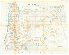
Important early Government Survey map of Oregon, based upon the General Land Office Surveys to date.
The map includes excellent detail west of the Cascades, with many early towns along the Willamettee (sic) River shown (Portland, Milwaukie, Oregon City, Linn City, Cleampoeg, Baynton, Salem, Albany, Corvallis, Eugene City) and a number of early roads shown as well.
East of the Willamette Merician is a region noted as heavily timbered ridges separated by immense ravines, extending to the Cascades and naming Mt Hood, Mutton Mountain, Mt Jefferson, Three Sisters, Diamond Peak, Virgin Lakes, Mount Pitt and Upper and Lower Klamath Lakes. East of the Cascades are Fremont's Routes, a Proposed Emigrant Route, Applegate's Trail, Immigrant Trail, Capt. Wallen's Route, the Trail to the Powder River, Meeks Trail, and notes regarding the Pah Ute Band of Snake Indians, several Indian villages and the proposed Guide Meridian.
![[Central Idaho & Eastern Oregon Letter Sheet Map] This Is Not A Map Of The World . . . The Weiser Commercial Club, Weiser, Idaho.](https://storage.googleapis.com/raremaps/img/small/40601.jpg)
![[ Northern Pacific Railroad ] NEW 7-30 GOLD LOAN OF THE Northern Pacific Railroad Co. SECURED BY FIRST MORTGAGE ON RAILROAD AND LAND GRANT. SAFE! PROFITABLE! PERMANENT!](https://storage.googleapis.com/raremaps/img/small/101828.jpg)