|
||

|

|
|

|
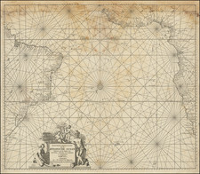
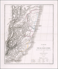
Fine detailed chart of the area around Rio De Janeiro, published by William Faden and engraved by J & C Walker for the British Admiralty.
The chart was first issued in 1821, in the year King Joao VI returned to Portugal and one year before Brazilian independence.
The chart is based upon surveys conducted under the auspices of the Portuguese Navy around the turn of the century. During the first half of the 19th Century, both British and American mariners were making frequent visits to Brazil's ports and sailing along its coastlines. Britain was a longtime ally of Portugal and maintained extensive trade links with ports such as Rio de Janeiro and Bahia. Vessels of the Royal Navy also frequently reprovisioned in Brazil before and after rounding Cape Horn. This chart would have been very useful during its time, as it would have been the first accurate general chart of Rio de Janeiro Harbor.
A great specimen of the early scientific maritime cartography of Brazil and a rare monument to contemporary large-scale chart publishing in America.
Includes sailing directions and a pencil annotations showing an approach via I. Rza or Flat Island and then on to the center of the Harbor.
This is apparently an early state of the chart, with a first state dated August 12, 1821.
Rarity
The Chart is very rare. We located an example of the first state in the British Library and note one example of the chart in a dealer catalog in 1989.
William Faden (1749-1836) was the most prominent London mapmaker and publisher of the late-eighteenth and early-nineteenth centuries. His father, William Mackfaden, was a printer who dropped the first part of his last name due to the Jacobite rising of 1745.
Apprenticed to an engraver in the Clothworkers' Company, he was made free of the Company in August of 1771. He entered into a partnership with the family of Thomas Jeffreys, a prolific and well-respected mapmaker who had recently died in 1771. This partnership lasted until 1776.
Also in 1776, Faden joined the Society of Civil Engineers, which later changed its name to the Smeatonian Society of Civil Engineers. The Smeatonians operated as an elite, yet practical, dining club and his membership led Faden to several engineering publications, including canal plans and plans of other new engineering projects.
Faden's star rose during the American Revolution, when he produced popular maps and atlases focused on the American colonies and the battles that raged within them. In 1783, just as the war ended, Faden inherited his father's estate, allowing him to fully control his business and expand it; in the same year he gained the title "Geographer in Ordinary to his Majesty."
Faden also commanded a large stock of British county maps, which made him attractive as a partner to the Ordnance Survey; he published the first Ordnance map in 1801, a map of Kent. The Admiralty also admired his work and acquired some of his plates which were re-issued as official naval charts.
Faden was renowned for his ingenuity as well as his business acumen. In 1796 he was awarded a gold medal by the Society of Arts. With his brother-in-law, the astronomer and painter John Russell, he created the first extant lunar globe.
After retiring in 1823 the lucrative business passed to James Wyld, a former apprentice. He died in Shepperton in 1826, leaving a large estate.
![A collection of five watercolor drawings from the Luso-Hispanic Border Commission in the Amazon Basin, drawn by its Spanish commanding officer: Parte del camino de tierra de Quito al R. Napo (Lamina I); Vista de la Poblacion y Fortaleza de S. Fran[is]co Xavier de Tabatinga (Lamina V); Vista del Salto grande del Rio Yapurà desde la dist.a de 3 Leguas (Lamina X); Vista del Grande Salto inaccesible del Rio Yapurá (Lamina XI); Los Pongos del Rio Marañon [Lamina XVIII].](https://storage.googleapis.com/raremaps/img/small/100698.jpg)