|
||

|

|
|

|
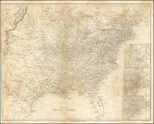
One of the rarest and most important of maps of Texas, and a foundation map for all future Texas cartography.
Hand-colored lithographed map of Texas, published in Houston, present here in the rare second edition, virtually unchanged from the first edition of the previous year.
Jacob de Cordova's map was produced on a far larger scale than any previous map of the state of Texas. De Cordova commissioned Robert Creuzbaur, an employee of the newly created General Land Office, to compile the map using the latest surveys held at the GLO. De Cordova's map was one of the first maps created with the resources of the GLO.
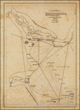
The map shows Cross Timbers, counties, colonies, roads, German settlements, land districts, trading posts, and exploration routes. Includes "Reference to Land Districts," official State of Texas seals, legend, and notes.
The map includes a certification by Sam Houston, Thomas Jefferson Rusk, David S. Kaufman and Timothy Pilsbury states
We, the undersigned, Senators and Representatives from the State of Texas, do hereby certify that we have carefully examined De Cordova's map of the State of Texas, compiled by R. Creuzbaur from the records of the General Land Office of Texas and have no hesitation in saying that no map could surpass this in accuracy and fidelity. It has delineated upon it every county in the State, its towns, rivers, and streams and we cordially recommend it to every person who desires correct geographical information of our state. To persons desiring to visit Texas, it will be invaluable.
Additional certifications are provided by:
- John C. Mays
- George T. Wood (Governor of Texas)
- W.D. Miller (Secretary of State)
- Thomas William Ward (Commissioner of the General Land Office)
- George W. Smyth (Commissioner of the General Land Office)
Sam Houston persuaded Congress to purchase 500 copies of the 1849 edition, arguing with Jefferson Davis in support of the quality of the map and character of De Cordova during the appropriations process on the floor of the Senate.
From 1849 to 1854, De Cordova published the map himself, before assigning the rights to J.H. Colton in 1855, who published the map from 1856 onward.
The 1850 Edition of the De Cordova Map
Among the post-1849 editions of the De Cordova, the 1850 must be considered the most valuable, as it is essentially unchanged from the first edition. There are two exceptions; the date now reads "1850" and the De Cordova's signature, which was initially rendered in manuscript, is now printed like the other signatures. It retains the same county configuration, as well as the same inset configuration, with Texas in its
In 1851, numerous changes are made to the map, most obviously in the inset, where Texas has taken on its "modern" configuration and the West has been reworked. In that edition, New Mexico runs all the way to the Pacific Ocean.
Institutional census:
- Streeter Collection, Beinecke Library, Yale University
Sale records:
- Sotheby's, December 7, 1999, sold for $74,000.
- Swann, 1999, sold for $70,000.
- Eberstadt, 1963, $275.
Jacob de Cordova
Jacob Raphael De Cordova (1808-1868), a native of Jamaica, was an early Texas land promoter and developer. De Cordova was one of the earliest Jewish settlers in Texas.
During the Texas Revolution, he supplied goods from New Orleans, before settling in Galveston in 1837. He quickly took to his adopted homeland, adding several Indian dialects to the English, German, French, Spanish, and Hebrew, which he spoke prior to his arrival.
In 1847, De Cordova was elected to the Texas House of Representatives from Houston, but he lost his bid for reelection in 1849. After serving his term in the Texas House of Representatives, De Cordova settled in Austin, where he and his brother published the Texas Herald. Anticipating a land boom in Texas following the Mexican War, he began speculating in real estate. For the next 20 years, he actively promoted immigration to Texas.
He was instrumental in promoting immigration to Texas through speeches, professing her wonders throughout the United States and as far away as England. As part of this campaign, he produced his first map of Texas in 1849. He also published a number of pamphlets and guidebooks including The Texas Immigrant and Traveller's Guide Book (1856) and Texas, Her Resources and Her Public Men (1858).
Working as a land agent, he, along with George B. Erath, laid out the town of Waco.
Rarity
The last two examples to sell at auction were offered in 1999, as noted above.