


|
||

|

|
|

|
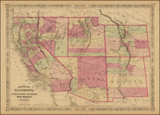
Illustrating the Proposed State of Deseret -- Including Its Port Towns of Los Angeles and San Diego
Fine large format map of Texas, California, New Mexico Territory, Utah Territory and contiguous regions, which includes a remarkably detailed outline of the propsed state of Deseret (Utah Territory), perhaps the single best illustration of this proposed Mormon State.
Kiepert's map of the Southwestern United States, first issued in 1847, provides a fascinating look at the changing features of the region. Over the course of approximately 20 years, the map was consistently updated to reflect the results of the explorations and surveys in the region, along with the changing geo-political borders from the Mexican-American War, Treaty of Guadalupue Hidalgo, Gadsden Purchase and the evolving Territorial Boundaries of the West, up to and immediately after the American Civil War.
This 1851 edition provides an excellent study of the evolution of the west. In addition to showing Deseret (see below), the map includes a pre-Gadsden Purchase boundary with Mexico and locates a the German, French and Mainzer Colonies in Texas, along with a number of early counties. The results of Fremont's Explorations and Surveys are in evidence. A number of Indian Tribes still appear, along with early routes through the west.
The map has four insets: on of the Gold Regions, one of Central America, one of the environs of Mexico City, and a profile of the heights across central Mexico. This map would have been issued for the German market, and it would have provided many an immigrant with a first look at his or her new country. The present example also includes two pages of text in German, including a footnote identifying the primary sources of the map (Map of Oregon and Upper California (Fremont), Military Reconnaissance of the Arkansas, Rio Del Norte and Rio Gila (Emory), Memoir of a Tour to Northern Mexico (Doniphan), and Expedition in 1846 and 1847 (Wislezenis), among others.
Brigham Young's State of Deseret
The provisional State of Deseret was founded in 1849 by Latter-Day Saint settlers in the Salt Lake city area. Brigham Young sent John Milton Bernhisel to Washington, D.C., to petition for territorial status, but later, in March 1849, elected to change the petition to a request for Statehood. The proposed state covered most of the lands from the Rocky Mountains and Oregon Territory to Mexico, extending west to the Sierra Nevadas and south to the Santa Monica Mountains, including Los Angeles and San Diego. While the provisional government met for several years, Utah Territory was formally created in 1851.
Map Source
The map appeared in Kiepert's Allgemeiner Hand-Atlas der Erde und des Himmels nach den besten astronomischen Bestimmungen, neuesten Entdeckungen und kritischen Untersuchungen entworfen. Rumsey notes "This is a marvelous atlas, full of interesting details."
Rarity
This is the first time we have ever seen the map.
![[ One of the First Printed Views of California ] A Remarkable Mountain near the River of Monterrey](https://storage.googleapis.com/raremaps/img/small/88071.jpg)
![(Mexican-Aztec Painting) [Watercolor of Aztec Deities from the Codex Telleriano-Remensis and Codex Vaticanus]](https://storage.googleapis.com/raremaps/img/small/103008.jpg)