


|
||

|

|
|

|
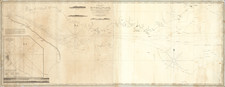
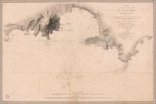
The First Urban Mapping of Montevideo Beyond The Old Town
A remarkable early manuscript plan of Montevideo, Uruguay during the earliest period of its urban history, showing for the first time the urban expansion of the town to the east of the Citadel and Ciudad Vieja. Created shortly before the British first invasions, this remarkable colonial map, drawn and colored by hand, illustrates the existing constructions outside the walls of the Citadel of Montevideo up to the line of the ejido in 1803.
Coming at a critical juncture in Montevideo's history, the map shows a scattered group of homes and buildings, without a formal street plan, clustered immediately to the east of the Citadel and fortified peninsula upon which Montevideo's old town is located. Perhaps most interesting is the color coding of the buildings on the map, showing the additional buildings constructed between 1799 and 1803 (buildings shaded in Yellow), providing two snapshots of the expanding future capital of Banda Oriental / Uruguay.
Among the more interesting features are the several slaughterhouses (Mataderos) located on the plan. In the earliest years of Montevideo, cattle were scarce, therefore, the meat trade was regulated and in 1741 the first slaughterhouse was established in an area outside the historic center.
Curiously, the map provides no signs of streets or fortifications, other than the outline of the Citadel. As such, it was almost certainly created for civil and local administrative purposes. There is not even the remotest suggestion of streets or roads on the map.
The area illustrated does not appear on either the 1783 Plano de la ciudad de Montevideo : situado a los 34° 55' en la América Meridional sacado el año de 1783 siendo Virrey el Exmo. señor Don Juan Jose de Vertis y Salzedo Thete. General de los Reas. Exercitos de S.M, or the map of Juan de los Reyes drawn in 1798, a reflection of both the recent expansion to the area and that the region shown was beyond the administrative core of the old city.
As noted by Fabricio Prado in Montevideo, A City Between Empires:
The Rio de la Plata region was one of the most contested areas in the Atlantic World during the eighteenth and early nineteenth centuries. Both Spain and Portugal claimed the area and it was an area of interest to the British. Montevideo–the best port and the most important city located on the northern bank of the Rio de la Plata–is the best example of the turbulent nature of the region. Originally founded by the Portuguese in 1723, the city was conquered and re-founded by the Spaniards in 1726. Later, the city became the most important port of the region, surpassing Buenos Ayres; it harbored not only Spanish ships, but also Portuguese, British, and French vessels. In 1806 and 1807, British troops occupied the city. Finally, during the revolutionary years between 1810 and 1828, Montevideo and the so-called Banda Oriental (the area now known as Uruguay) were fought over by loyalists and the revolutionary forces of the local caudillo, José Artigas. In 1816, Portuguese troops occupied the area and incorporated the region as the Portuguese Província Cisplatina. A group (backed by Argentina) instigated a war in 1825 against the Brazilian empire. Britain, to protect its commercial interests in the region, brokered peace between the many warring parties and Uruguay was created as a buffer state in the region in 1828. . . .
As the map's primary function is identifying the owners of the structures illustrated on the map, it would seem the purpose must have been for local administration. Each structure is numbered and identified with the name of the owner or identifying its public use.
Includes a list of 151 places, mostly the homes of early residents, but also including
- 18. Aguada de la Marina
- 34. Casilla de los Guardas
- 81. Escuela Practica
- 82. Horno de Biana
- 91. Matadera de Ciera
- 92. Quartel de los Indios
- 96. Matadero de Manuel Perez
- 97. Almazenes de Ribera
- 98. Cuerpos de Guardia
- 99. Espaladon de la Escuela Practica
- 104. Matadero de Silba
- 106. Quartel de Blandengs
- 113. Fte Junto a la Cuidadela
- 116. Teronima del Balle?
- 124. Almazenes de la Obra del Rey
- 148. Pozos de la Policia
- 149. Alta que domina esta Plaza
- 150. Ciudadela
- 151. Una parte del Resinto
At the end of the list, there is a note that reads:
Nota. Las casas dadas de Amarillo se han edificado desde el ano de 1799. hasta el presente 1803.
Translation: The houses in yellow were built between 1799 and 1803.
Early Montevideo History
Between 1680 and 1683, Portugal founded the city of Colonia do Sacramento, across the bay from Buenos Aires. This city met with no resistance from the Spanish until 1723, when they began to place fortifications on the elevations around Montevideo Bay. In November 1723, Portuguese Field Marshal Manuel de Freitas da Fonseca built the Montevieu fort.
A Spanish expedition was sent from Buenos Aires and in January 1724, the Spanish forced the Portuguese to abandon the location and started populating the city, initially with six families from Buenos Aires and soon thereafter by families arriving from the Canary Islands who were known as Guanches or Canarians. There was also one significant early Italian resident by the name of Jorge Burgues.
A census of the city's inhabitants was performed in 1724 and a plan was drawn delineating the city and naming the city San Felipe y Santiago de Montevideo, later shortened to Montevideo. The census counted fifty families of Galician and Canary Islands origin, more than 1000 indigenous people, mostly Guaraní, as well as Black African slaves of Bantu origin. By 1729, a second group of settlers had arrived from the Canary Islands.
In 1726, Pedro Millan distributed land to the settlers, but large sections of the original site were reserved for a church and other official buildings on a plaza, and a strong fortress. In January 1730, Bruno Zabala set up the first cabildo (council).
A few years after its foundation, Montevideo became the main city of the region north of the Río de la Plata and east of the Uruguay River, competing with Buenos Aires for dominance in maritime commerce. The importance of Montevideo as the main port of the Viceroyalty of the Río de la Plata brought it in confrontations with the city of Buenos Aires in various occasions, including several times when it was taken over to be used as a base to defend the eastern province of the Viceroyalty from Portuguese incursions.
By 1770, the population had grown to 7,000 and to nearly 10,000 by 1800, approximately 25% of which were black or mixed race.
In 1776, Montevideo was selected as the Armada Real’s principal naval base (Real Apostadero de Marina) for the South Atlantic. By the end of the century, the Old Town (Ciudad Vieja) had developed on the peninsula located along the eastward side of the harbor. However, in the ensuing years, the city was variously invaded, besieged and contested by several different parties during the Napoleonic Wars and the Rebellions against Spanish rule that had swept across Latin America.
In February 1807, British troops under the command of General Samuel Auchmuty and Admiral Charles Stirling occupied the city during the Battle of Montevideo (1807), but it was recaptured by the Spanish in September 1807, when John Whitelocke was forced to surrender to troops formed by forces of the Banda Oriental and of Buenos Aires. After this conflict, the governor of Montevideo Francisco Javier de Elío opposed the new viceroy Santiago de Liniers, and created a government Junta when the Peninsular War started in Spain, in defiance of Liniers. Elío disestablished the Junta when Liniers was replaced by Baltasar Hidalgo de Cisneros.
The Banda Oriental was annexed to Brazil in 1816, something resented by the majority Spanish-speaking population. However, the people eventually won their independence, founding the new República Oriental del Uruguay in 1828, with Montevideo as the capital.
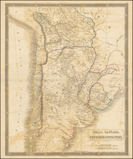
![[ Argentina & Uruguay ] La Plata](https://storage.googleapis.com/raremaps/img/small/97143.jpg)