


|
||

|

|
|

|
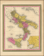
A fine example of Pieter Mortier's map of Eastern Italy which includes the Kingdoms of Naples and Sicily. The map details the surrounding areas of Italy such as the Dalmatian Islands in the Adriatic, the Aeolian Islands north of Sicily in the Tyrrhenian Sea, the island of Corfu to the southeast, etc.
The map also includes an inset of the southern portion of Sicily detailing the areas of Mazara del Vallo to the southwest and Val di Noto to the southeast.
A beautifully engraved title cartouche is featured at the top right of the map. Two directional compasses are also included within the Adriatic Sea.
Pierre, or Pieter, Mortier (1661-1711) was a Dutch engraver, son of a French refugee. He was born in Leiden. In 1690 he was granted a privilege to publish French maps in Dutch lands. In 1693 he released the first and accompanying volume of the Neptune Francois. The third followed in 1700. His son, Cornelis (1699-1783), would partner with Johannes Covens I, creating one of the most important map publishing companies of the eighteenth century.
![Elba [and] Sicilia](https://storage.googleapis.com/raremaps/img/small/66222.jpg)
![[ Sicily / Sardinia ] Septima Europe Tabula](https://storage.googleapis.com/raremaps/img/small/101893.jpg)
![[Vesuvius] Pâtes alimentaires au Vésuve](https://storage.googleapis.com/raremaps/img/small/89595.jpg)