|
||

|

|
|

|
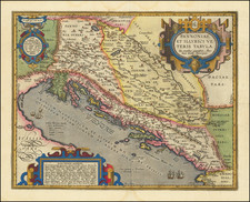
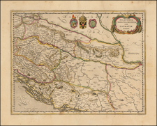
Striking large and highly detailed map of the Gulf of Venice, Adriatic and contiguous coastline of the Balkans, extending south to Corfu.
Includes two large cartouches.
The title cartouche shows plans of Venice and 22 other cities in small medallions.
The map credits Coronelli and Sanson as the source for the map.
Pierre, or Pieter, Mortier (1661-1711) was a Dutch engraver, son of a French refugee. He was born in Leiden. In 1690 he was granted a privilege to publish French maps in Dutch lands. In 1693 he released the first and accompanying volume of the Neptune Francois. The third followed in 1700. His son, Cornelis (1699-1783), would partner with Johannes Covens I, creating one of the most important map publishing companies of the eighteenth century.
![[ Greece, Bulgaria, Albania, Macedonia, Serbia & Turkey ] Tabula Europae IX](https://storage.googleapis.com/raremaps/img/small/74916.jpg)