


|
||

|

|
|

|
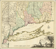
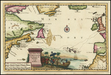
Bernard Romans' Map of Connecticut -- A Revolutionary War Era Rarity
Important early map of Connecticut and Long Island, originally published in New Haven by Bernard Romans and later in Amsterdam.
This map was one of four Romans maps parts of the American colonies to be re-engraved and published by the renowned Dutch firm of cartographers Covens and Mortier and Covens Jr. in 1780. The Covens & Mortier edition of Romans' map is the only surviving evidence of what was almost certainly the now lost second state of Romans' map of Connecticut, prior to the revisions in Litchfield County and New London County. As such, the first state, which survives in a single copy at the John Carter Brown Library appears to be a proof state, pre-dating the inclusion of additional contour lines in the rivers, lakes and coastlines of Connecticut. The Covens & Mortier edition is identical to the first state, except that it adds these contour lines. A more complete description of the states appears at the bottom of this description.
First advertised in a request for subscribers shortly after the British attack on Danbury, Connecticut (April 26, 1777) and the Battle of Ridgefield, Connecticut (April 27, 1777), it would seem almost certain that Romans specifically had in mind production of an up to date map of Connecticut for use in the defense of the Colony as his catalyst creation of the map. The first advertisement announcing Romans intent to seek subscribers and publish his map appeared in the Boston Gazette, and Country Journal of May 19, 1777, barely 3 weeks after these skirmishes, at a time when Connecticut residents were no doubt preparing for further British incursions. First notice of the map's publication occurred on June 11, 1777.
Romans was one of the most talented and influential American mapmakers of the late colonial and early Revolutionary War period. As described below, both before the American Revolution, while Romans was serving as one of the leading British Surveyors in the Colonies and after the start of the American Revolution, by which time Romans' allegiance had switched to the cause of the American colonists and he had become actively involved in the earliest campaigns of the American Revolution, Romans played an important role in the mapping of America.
While Romans role in the British Surveys and his publications on the Gulf Stream and other topics are well known, his cartographic contributions in support of the American Revolution have been far less systematically reported and studied. It is relatively well known that Romans was part of the leadership that seized Fort Ticonderoga and Fort George in 1775 and that Romans plan for the defense and fortification of West Point was submitted to the Continental Congress in the first years of the war. However, relatively little has been written about his private publication in New Haven of several remarkable maps in aid of the American cause and his role as a mapmaker for the Continental Army, under the command of Robert Erskine. Little has been reported about Romans during this period, despite the fact that a number of his manuscript maps of important campaign theatres are held in the collections of the Library of Congress, New York Historical Society, etc.
While little information survives about the creation of Romans map of Connecticut, a systematic study of the map reveals that it is based upon the 1768 Moses Park map of Connecticut, which until Romans map was the most important map of Connecticut. The content of the map suggests that Romans utilized his travels, especially in Western Connecticut and the Hudson River Valley in aid of the American Revolutionary cause to significantly improve and update the Park map, with his likely intent being to create a map in aid of Connecticut's defense from prospective British invasions, at a time when no suitable map existed.
Another important clue regarding its publication appears in one of the advertisements noted below, the first advertisement to include Romans' name in connection with the map where the map is described as being a map showing the area "that has been the late Seat of War."
Romans Map of Connecticut
The map shows Connecticut, with a small part of Rhode Island to the east, Long Island Sound and Long Island to the south, and part of New York State to the west. Counties, cities, towns, rivers, lakes, ponds, and islands are shown. Rows of peaks are used to indicate hills and mountains. New York is identified as "State of New York."
Connecticut is shown divided into six counties, each of which is outlined in color, with the main towns colored in red. The beautiful vignette-cartouche containing the title (in the lower right corner) is of a naturalistically presented Connecticut village scene.
As noted above, the content is a significantly improved and updated version of Moses Park's 1768 map of Connecticut. Romans and Park almost certainly knew each other, having both served in Captain Edward Mott's Company. The rest of the information was almost certainly added from Romans travels and cartographic research in the region between 1775 and 1777, in aid of the Revolution.
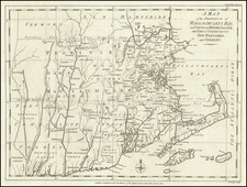
Moses Park's 1766 Map of Connecticut
In 1765, Moses Park of Preston (assisted by Asa Spaulding of Norwalk and Samuel Mott of Preston) surveyed and drafted the oldest printed map drawn in Connecticut by a Connecticut resident that portrayed the colony. Its engraver and printer are unknown. According to Edmund Thompson’s Maps of Connecticut, the map was commissioned by the Connecticut Colonial government.
Dedicated to the Earl of Shelbourne, the map was a tremendous improvement over the cartographical details of earlier maps covering the region, most notably Jeffery's Map of the Most Inhabited Part of New England . . . which was until then considered the most authoritative printed map of the region.
A link to the Park map can be found here: https://commons.wikimedia.org/wiki/File:Plan_of_the_Colony_of_Connecticut,_Moses_Park,_1766.jpg
Updating the Moses Park Map
At the outset of the American Revolution, there was a need to update and improve Park's map. Following the British capture and control of Long Island in 1776, the coastline of Connecticut was always a potential battle front. The waters of Long Island Sound separated Connecticut from enemy territory, with the shores constantly exposed to attack. Connecticut's coast was a regular scene of British harassment, ranging from small skirmishes to invasions involving hundreds of British Troops, with Fairfield, Norwalk and New London nearly destroyed during such attacks.
Romans Map of Connecticut significantly improves upon the work of Moses Park, whom Romans likely met through Captain Edward Mott, with whom both men served in 1775 and 1776. In the most general terms, the Romans map is far more detailed, with additional place names, roads and topographical details not found in the Moses Park Map. Romans also continued to provide information across the boundaries into the neighboring colonies of New York, New Jersey, Rhode Island, along with a complete image of Long Island, making it a far more valuable general tool for military planning.
Another critical difference between the Park map and Romans map is Romans emphasis on the width and navigability of rivers. While Park's map makes no effort to illustrate the navigability of Connecticut's rivers (except the Connecticut River and the Thames and Quinabogue Rivers), Romans provides a differentiated sense of the magnitude of water flowing through many of Connecticut's primary rivers.
Similarly, Romans provides significantly more topographical information in his map, giving a sense of the river valleys and hills throughout the Colony.
While Park's map shows only a road along the coast, a road running from New Haven to Hartford and two roads tracking north from Hartford along the Connecticut River, Romans' map shows a number of roads traversing east and west through the Colony and shows far more roads than the Park map. Romans also identified Copper Mines, Iron Works and a Furnace in the northern part of Connecticut.
Other Sources
One other possible source for the map is the survey work conducted during the American Revolution by Romans and others in the first 2 years of the War. As early as 1775, Romans had been working under the orders of several Colonial Safety Committees and later under General Washington and the Continental Congress on plans for the fortification of strategic places in New York and Connecticut, most notably his set of 3 manuscript maps for the fortification of the area around West Point. Romans was active in the region from 1775 to 1780, when he resigned his commission. Given his skills, it would seem almost certain that in addition to the known manuscript maps in the Library of Congress, New York Historical Society and other places in his hand, he would have had the requisite material necessary to augment the work of Moses Mark.
As noted by Cappon:
When [George] Washington took command of the Continental Army on July 2, 1775, cartographic tools for prosecuting an impending war were conspicuously lacking. The colony-wide and regional maps, which we have reviewed, may have proved useful in providing generalized information for problems of strategy, but they were far less serviceable for troop movements, encampments, and tactical purposes. On a local scale the colonies had produced nothing comparable to the maps of English counties prepared from actual surveys during this same period. Furthermore, the most highly trained engineers and surveyors were serving in the British Army, a number of them natives of Continental countries where such training was closely integrated with the military. Under the circumstances confronting Washington, his procedure was perforce empirical, his first efforts discouraging. During the first phase of the War, in New York and New Jersey, he had tried in vain to procure accurate maps, but, he informed the President of the Continental Congress, ' [I] have been obliged to make shift, with such Sketches, as I could trace from my own Observations, and that of Gentlemen around me."
Fortunately a few months later Washington . . . Robert Erskine, who had migrated to New Jersey in 1771 to manage an iron works financed by British capital, but had turned American patriot and become a militia captain. Washington offered him the position of Geographer and Surveyor-General to the Continental Army and he was commissioned in July 1777. Erskine's immediate need was for 'Young gentlemen of Mathematical genius, who are acquainted with the principles of Geometry, and who have a taste for drawing.' His first assistant was the Pennsylvania cartographer, William Scull, during the year 1777-1778; then in June 1778 Erskine appointed as Assistant Geographer Simeon DeWitt, a recent graduate of Queen's College, who became head of the office on Erskine's untimely death in 1780. The following May, Congress appointed a Geographer to the Southern Army, Capt. Thomas Hutchins, ex-British officer, who would soon enter upon a noteworthy civilian career.
The office of Erskine and DeWitt employed some fifty men as surveyors for various periods during the war, most of them with little or no previous experience, laying out practical routes for troop movements as the fighting shifted from New Jersey and Pennsylvania to Virginia. Among this miscellaneous lot of employees, most of them veiled in the obscurity of the common man, one finds Bernard Romans, Pierre Du Simitière, and John Trumbull, son of the governor of Connecticut.
From an early date, Erskine's team was making maps of the Hudson Valley and Western Connecticut. One example is a map in the New York Historical Society entitled: Surveys in New York and Connecticut States, for his Excellency Gen. Washington, by Robert Erskine, F.R.S. Anno 1778 W. Scull delin.
The details of Romans map, like those created by the Erskine/Scull manuscript above continue beyond the Colonial border, with exceptional detail in Long Island, New York, New Jersey and Rhode Island.
For the Western part of Long Island, Romans draws upon Montresor's Map of the Province of New York, with part of Pennsylvania, but for the eastern most part of Long Island, Romans appears to draw from a different and more advanced source.
Publication
Bernard Romans map was first advertised for sale in the June 11, 1777 edition of the Connecticut Journal, without Romans name and later, with Romans name, in the Connecticut Gazette, and the Universal Intelligencer, October 31, 1777, advertised as follows:
Just published, and to be sold by T. GREEN. [PRICE TWO DOLLARS]
ROMAN'S MAP Of the State of Connecticut, with the Parts of New-York, New-Jersey, and Islands late Seat adjacent that has been the late Seat of War.
The map however was clearly in the works as early as April 1777, when the following advertisement appeared in the Boston Gazette, and Country Journal of May 19, 1777:
PROPOSALS For PRINTING "A New MAP of the STATE of CON NECTICUT, with some of the adjacent Parts of the States of New-York, New- Jersey, and Rhode-Island; collected from the best and latest Surveys.
CONDITIONS.
1. The Plate will be 24 Inches, by 16 in Size.
2. The Price to Subscribers to be One Dollar plain, or Ten Shillings properly coloured.
3. It will not be delivered to Non-Subscribers under Eight Shillings plain, or Twelve colour'd.
4. It will be published in about four Weeks from this Date.
5. Those who subscribe for six Sets shall have one gratis.
N.B. If this Work meets due Encouragement, the Author intends publishing other useful Maps.
Subscriptions are taken in by the Printer hereof.
New Haven, April 21, 1777."
Bernard Romans
Bernard Romans was born in Delft, Netherlands about 1720. He learned mapmaking and surveying in England, before moving to the Colonies in 1757. He served as a Surveyor in Georgia, where he would rise to become Deputy Surveyor General in 1766 and one of the most important Colonial mapmakers. He is perhaps best known for his extensive survey and mapping of the Coastal Waters of East Florida. William Gerard De Braham, the Surveyor General for the Southern Colonies appointed him Deputy Surveyor General for the Southern District in 1773 and wrote A Concise Natural History of East and West Florida, published in 1775, one of the most important works on Florida.
When war broke out in 1775, Romans was in Boston where Paul Revere was engraving Romans' maps of Florida. Romans enlisted in the American cause and was appointed a Captain and served with Benedict Arnold and Nathaniel Greene in their attacks on Fort George and Fort Ticonderoga. Following the Battle of Bunker Hill, Romans published An Exact View of the Late Battle of Charleston, June 17, 1775, and a map of the area around Boston, entitled The Seat of War In America, which he dedicated to John Hancock.
Romans served until June 1778, when he resigned his commission. He rejoined the Southern Campaign in 1780, during which time he was captured by the Royal Navy and imprisoned until the end of the War. He died returning home after the War in 1784 (one account put forth by his family is that he was murdered and thrown overboard).
Romans published several other significant maps of the American Revolution in New Haven, each of which is essentially unobtainable. In 1778 Romans advertised for sale A Chorographical Map of the Northern Department of North America and A Chorographical Map of the Country Round Philadelphia. He also published Connecticut and parts adjacent, with Abel Buell.
The appearance of three of the Romans maps in editions published in Amsterdam shortly after the publication of the original New Haven versions of the map is a topic worthy of investigation. It is reasonable to speculate that Romans used his Dutch roots to have a set of the maps sent back to Amsterdam for publication.
States of the Map
Romans 1777 map is known in five examples. Thompson identifies two states and surmises from the Covens & Mortier details the existence of an intermediate state between the two referenced below.
First State: John Carter Brown Library. Apparently, a proof state. The Lakes, Rivers and Coastlines of Connecticut are represented in a more simple outline fashion, without contour line. However, it should be noted that the rivers are not noted with single lines, the widths of the rivers is unchanged in later states and only contour lines are added within. Westbury is erroneously shown south of Waterbury and Southbury is placed on the east side of the Naugatuck River.
Second State: No known examples, but almost certainly the source for the Covens & Mortier map.
Third State: The Shepard River and the Pomperaug River are completely reworked north of the Housatonic River. Westbury is now north of Waterbury and Southbury is now on the east side of the Naugatuck River. The towns of Goshen and Westchester have been added (south of Lebanon). Stony Brook in Suffield County and Fresh Water Brook in Enfield have been added, along with some ponds in East Haven and Southbury. Connecticut Historical Society, Richard Brown Collection (illustrated online in the Leventhal Collection), Huntington Library, Lund University (Sweden).
Rarity
A copy of the original Romans sold in June 2011 at Swann Galleries for $168,000.
Only a single example of this 1780 version is recorded as having been sold at auction in the past thirty years.
Covens & Mortier was one of the largest and most successful publishing firms in Dutch history and continued in business for over a century. Pierre Mortier the Elder (1661-1711) had obtained a privilege in 1690 to distribute the works of French geographers in the Netherlands. After his widow continued the business for several years, Cornelis (1699-1783) took over in 1719.
In 1721, Mortier forged a partnership with Johannes Covens (1697-1774), who had recently married Cornelis’ sister. They published under the joint name of Covens & Mortier. Johannes continued to work with Cornelis’ heirs after his death. In 1774, upon the death of his father, Johannes Covens II (1722-1794) took over his father’s share. In 1778, the company changed its name to J. Covens & Zoon, or J. Covens & Son.
Covens II’s son, Cornelis (1764-1825), later inherited the business and brought Petrus Mortier IV back into the fold. Petrus was the great-grandson of Petrus Mortier I. From 1794, the business was called Mortier, Covens & Zoon, or Mortier, Covens, & Son.
The business specialized in publishing French geographers including Deslisle, Jaillot, Janssonius, and Sanson. They also published atlases, for example a 1725 reissue of Frederik de Wit’s Atlas Major and an atlas, with additions, from the works of Guillaume Delisle. There were also Covens & Mortier pocket atlases and town atlases. The company profited from acquiring plates from other geographers as well. For example, the purchased Pieter van der Aa’s plates in 1730. Finally, they also compiled a few maps in house. At their height, they had the largest collection of geographic prints ever assembled in Amsterdam.

