|
||

|

|
|

|
Two-sheet Theater of war map of Northern Italy, published in Amsterdam, circa 1700. This is the first state of the map, which was later re-issued with the Covens & Mortier imprint, circa 1720.
This map was created to show the plan of attack for Prince Eugene of Savoy (1663-1736), main commander of the forces of the Holy Roman Empire in the War of Spanish Succession (1701-14). The war was a struggle for the dominance of Europe. It opposed Louis XIV of France against a coalition including England, Holland and the Holy Roman Empire. Much of the first fighting took place in northern Italy.
The map illustrates the different areas of conflict throughout Northern Italy. The map on the left contains a beautiful pictorial engraving of Eugene conducting military operations in the Alps and the capture of Marshal François de Neufville de Villeroy, in the night of January 31, 1702 to February 1, 1702. The map is centered on Milan and shows the pathways, roads, mountain ranges and waterways the armees traveled through from the Alps down to Genoa.
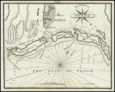
The map on the right extends from Germany (Bavaria) and Austria in the north to the Gulf of Venice in the east and south to Tuscany. It details the major roads, mountain ranges and cities the armees navigated through. Key cities are highlighted in red, including Vicenza, Verona, Mantua, Paduan, Venice, Bologna, Modena, etc. Lago Di Garda and Lac D'Idro are also featured on the map.
Both maps identifiy churches, universities, mountain ranges, lakes, castles, chateaus, etc.
The map also features a cartouche with a scale of distance.
Pierre, or Pieter, Mortier (1661-1711) was a Dutch engraver, son of a French refugee. He was born in Leiden. In 1690 he was granted a privilege to publish French maps in Dutch lands. In 1693 he released the first and accompanying volume of the Neptune Francois. The third followed in 1700. His son, Cornelis (1699-1783), would partner with Johannes Covens I, creating one of the most important map publishing companies of the eighteenth century.
![Rhetiae alpestris descriptio in qua hodie Tirolis Comitatus [with] Goritiae, Karstii, Chaczeolae, Carniolae, Histriae, et Windorum Marchae Descrip.](https://storage.googleapis.com/raremaps/img/small/83989.jpg)
![[Vercelli] Urbis Vercellensis a Carolo Emmanuele II](https://storage.googleapis.com/raremaps/img/small/89098.jpg)