|
||

|

|
|

|
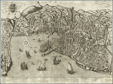
Detailed map of Padua, Italy. Includes the Province of Rovigo and the Gulf of Venice. The map illustrates the islands, roads, pathways, valleys, mountainous regions, forests and waterways the Italian and French armies used to navigate through the region. The map highlights the towns of Padua, Vincenza, and Venice.
The map features churches, chateaus, agricultural areas, lakes, universities, military ships, etc. Also includes a compass and scale of distance.
Published in Amsterdam, circa 1700.
Pierre, or Pieter, Mortier (1661-1711) was a Dutch engraver, son of a French refugee. He was born in Leiden. In 1690 he was granted a privilege to publish French maps in Dutch lands. In 1693 he released the first and accompanying volume of the Neptune Francois. The third followed in 1700. His son, Cornelis (1699-1783), would partner with Johannes Covens I, creating one of the most important map publishing companies of the eighteenth century.
![[ Villa Farnese ] Caprarola Arx et Horti Farnesiani](https://storage.googleapis.com/raremaps/img/small/96849.jpg)
![(Tyrol, etc.) Tirolensis Comitatus: Seu partis Rhetiae Alpestris insignis descriptio Ch[orog]aphica [and] Carniolae Chaziolae que Ducatus Nec Non et Goritiae Comitatus](https://storage.googleapis.com/raremaps/img/small/75387.jpg)
![[Vercelli] Urbis Vercellensis a Carolo Emmanuele II](https://storage.googleapis.com/raremaps/img/small/89098.jpg)