|
||

|

|
|

|
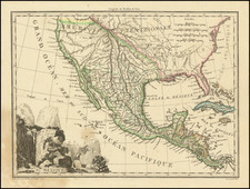
The Theater of War in the Gulf of Mexico During The War of Spanish Succession
Fine example of the first state Pierre Mortier's spectacular map of Florida, the Gulf Coast, Texas, Central America and part of Cuba, published during the War of Spanish Succession (1702-1714).
The first state of the map includes an inset map showing the Island of St. Jean, off the coast of Vera Cruz and primitive coastal detail for the area east of the Orinoco River. The second state includes 4 different inset maps, covering Vera Cruz, Havana, Porto Bello and the Isthmus of Panama, replacing a completely engraved section of the map to the east of the Orinoco River.
The map is a curious amalgam of cartographic information along the Gulf Coast. The source of the Mississippi appears near Corpus Christi, a vestige of La Salle and Franquelin's work in the early 1680s and thereafter followed by Rossi, Coronell, Roillard, De Fer and Morden in the 1690s. However, the eastern Gulf and Florida configuration follows Mount & Page's Chart of the Bay of Mexico, eschewing the archipelago of Florida, which was later followed by Moll in 1715 and later Popple.
A remarkable feature of the map is the enormous, superbly detailed and designed vignette showing full-scale naval battle between the French and Dutch navies. Indian laborers are shown mining gold and silver in the mountains, while on the shore below Europeans pack gold bars and jewels into a treasure chest. The route followed by the Spanish gold and silver fleets is shown, and there is an inset in top right of St. Jean e Lucu offshore the coast of Vera Cruz. Florida is called Tegeste Province on the map.
One of the most decorative maps of the region published in the first half of the 18th Century.
Pierre, or Pieter, Mortier (1661-1711) was a Dutch engraver, son of a French refugee. He was born in Leiden. In 1690 he was granted a privilege to publish French maps in Dutch lands. In 1693 he released the first and accompanying volume of the Neptune Francois. The third followed in 1700. His son, Cornelis (1699-1783), would partner with Johannes Covens I, creating one of the most important map publishing companies of the eighteenth century.
![(Florida, the Bahamas, and Cuba) Southern Coast U. States. Sheet VI. [joined with:] Southern Coast, U. States. Sheet VIII. [and:] Cuba and the Windward Passages](https://storage.googleapis.com/raremaps/img/small/85747.jpg)

![(Panoramic photograph) Camp Travis, Tex. 9/8/1918 East Side [WWI Camp Travis, near San Antonio, Texas, African American Troops]](https://storage.googleapis.com/raremaps/img/small/87312.jpg)
![Map of Mexico, Central America, and the West Indies [Insets of Bermuda, Sandwich Islands, Jamaica and Panama Railroad]](https://storage.googleapis.com/raremaps/img/small/78369.jpg)