


|
||

|

|
|

|
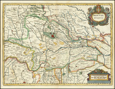
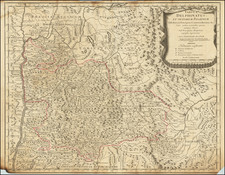
The map offers a detailed representation of the Duchy of Ferrara in Italy.
The map shows Ferrara a century after is incorporation into the Papal States in 1598, following the extinction of the Este ducal line. Its cultural significance persisted, though its political power waned.
A primary feature of the map is its depiction of roads and pathways, showcasing the routes the Italian and French armies took. These routes underline Ferrara's strategic importance to both powers, acting as channels of communication and movement.
Further detailing the region's preparedness and past confrontations are the fortified zones, particularly evident in Ferrare and Bologna. Such zones highlight the region's need for protection and the prominence of military strategy. Around the turn of the 18th century, the Italian and French armies were embroiled in the War of the Spanish Succession (1701-1714). This war started over who should succeed the childless Charles II as King of Spain, and it involved most of the major European powers of the time.
-
Background: The last Habsburg King of Spain, Charles II, died in 1700 without an heir. In his will, he left the entire Spanish Empire to Philippe, Duke of Anjou, who was the grandson of King Louis XIV of France. This threatened to unify the vast Spanish Empire with the already powerful French one, thereby upsetting the balance of power in Europe.
-
Italian Theatre: Italy became a major battleground during this war due to the Spanish possessions in Italy, particularly the Duchy of Milan and the Kingdom of Naples. Both France and Austria aimed to control these territories.
It's worth noting that during the War of the Spanish Succession, various powers (including Dutch, English, Austrian, and Spanish troops) aligned themselves against the French and their allies in different theatres of war, including Italy.
Beyond the political and military dimensions, the map provides insight into the daily life of Ferrara's inhabitants. Churches dot the landscape, indicating the importance of religion. Chateaus, symbols of the nobility and perhaps remnants of the Este era, are marked with precision. The agricultural zones suggest the region's primary economic activity, while the presence of universities indicates a commitment to academic excellence.
Pierre, or Pieter, Mortier (1661-1711) was a Dutch engraver, son of a French refugee. He was born in Leiden. In 1690 he was granted a privilege to publish French maps in Dutch lands. In 1693 he released the first and accompanying volume of the Neptune Francois. The third followed in 1700. His son, Cornelis (1699-1783), would partner with Johannes Covens I, creating one of the most important map publishing companies of the eighteenth century.
![[ Duchy of Milan ] Ducatus Mediolani una cum Confinus accurata Tabula . . .](https://storage.googleapis.com/raremaps/img/small/60253.jpg)