


|
||

|

|
|

|
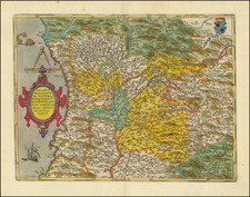
Detailed map of the Duchy of Mantua in Italy. Includes roads, pathways, mountainous regions and forests the Italian and French armees used to navigate through the region. The map also illustrates fortified zones colored in red, such as Mantua, Rever, Castiglione, Printe de Bozolo, Parme, Bressello, etc.
The map features churches, chateaus, agricultural areas, lakes, universities, etc. Also includes a decorative military illustration at the bottom right of the map with a scale of distance.
Published in Amersterdam circa 1700.
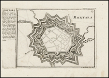
Pierre, or Pieter, Mortier (1661-1711) was a Dutch engraver, son of a French refugee. He was born in Leiden. In 1690 he was granted a privilege to publish French maps in Dutch lands. In 1693 he released the first and accompanying volume of the Neptune Francois. The third followed in 1700. His son, Cornelis (1699-1783), would partner with Johannes Covens I, creating one of the most important map publishing companies of the eighteenth century.
![(War of the Holy League - Siege of Vicovaro) Il Vero Disegno di Vicovaro Occupato da Imperiali et Recuperato Dalla Chiesa a di XIIII Febraro, M D L VII [The True Design of Vicovaro Occupied by the Imperials and Recovered by the Church on the 14th of February, 1557]](https://storage.googleapis.com/raremaps/img/small/75420.jpg)