|
||

|

|
|

|
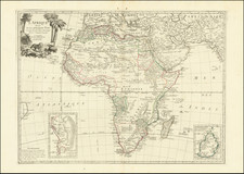
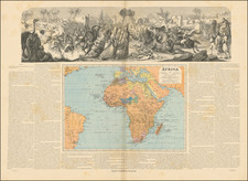
Decorative 2-sheet map of Africa, from the leading English mapmaker of the period.
The map shows the whole continent as well as Madagascar, portions of the coast of Asia, Ceylon, India, and Brazil. An inset view of the Cape of Good Hope, showing the bay filled with ships, Table Mountain and a key to the locations are noted. The three other insets include Cape Coast Castle on the Gold Coast of Guinea, James Fort on St. Helena, and a plan of the Fort of Good Hope.
Includes a fascinated note in Guinea, I am credibly informed that ye country about 400 leagues North of the Coast of Guinea is inhabited by white Men, or at least a different kind of People from the Blacks, who wear Cloaths, and have ye use of Letters, make Silk, and that some of them keep the Christian Sabbath. The old sources of the Nile, and Lakes Zaire and Zaflan, have been turned into swamps and are no longer connected to the Nile. The sea is filled with indications of currents, as well as a good route to take to the East Indies from England. Decorated with a lovely compass rose and a cartouche that has a native wrestling a crocodile, an ostrich, two battling snakes, a lion and an elephant.
Herman Moll (c. 1654-1732) was one of the most important London mapmakers in the first half of the eighteenth century. Moll was probably born in Bremen, Germany, around 1654. He moved to London to escape the Scanian Wars. His earliest work was as an engraver for Moses Pitt on the production of the English Atlas, a failed work which landed Pitt in debtor's prison. Moll also engraved for Sir Jonas Moore, Grenville Collins, John Adair, and the Seller & Price firm. He published his first original maps in the early 1680s and had set up his own shop by the 1690s.
Moll's work quickly helped him become a member of a group which congregated at Jonathan's Coffee House at Number 20 Exchange Alley, Cornhill, where speculators met to trade stock. Moll's circle included the scientist Robert Hooke, the archaeologist William Stuckley, the authors Jonathan Swift and Daniel Defoe, and the intellectually-gifted pirates William Dampier, Woodes Rogers and William Hacke. From these contacts, Moll gained a great deal of privileged information that was included in his maps.
Over the course of his career, he published dozens of geographies, atlases, and histories, not to mention numerous sheet maps. His most famous works are Atlas Geographus, a monthly magazine that ran from 1708 to 1717, and The World Described (1715-54). He also frequently made maps for books, including those of Dampier’s publications and Swift’s Gulliver’s Travels. Moll died in 1732. It is likely that his plates passed to another contemporary, Thomas Bowles, after this death.