The item illustrated and described below is sold, but we
have another example in stock. To view the example which
is currently being offered for sale, click the
"View Details" button below.
1867 circa Julius Bien & Co.
$ 375.00


|
||

|

|
|

|
Stock# 56419
Description
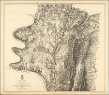
Highly detailed battle plan of the battle of Antitiem, published shortly after the conclusion of the Civil War.
The map consists of a detailed treatment of environs of Sharpsburg showing roads, the "Washington Co. R.R.," fences, houses, names of residents, vegetation, drainage, villages, the "Burnside Bridge," "Bloody Lane," "Dunker's Chapel," "National Cemetery," and relief by hachures.
![(Kentucky Borderlands) [An original manuscript account detailing a trip to and from Kentucky via the Ohio River, including the return trip via the Old Wilderness Trail, with two hand-drawn plat maps] An Account of Expences in Travelling to and from Kentucky in search of Land Claimed by Mr. H. McClery & Myself.](https://storage.googleapis.com/raremaps/img/small/81445.jpg)
![[Sorority? Hazing in 1931] Cognization to the Class of 1935. . .](https://storage.googleapis.com/raremaps/img/small/81014.jpg)