


|
||

|

|
|

|
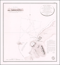
An Early Promotional Map For Chile's Second Railroad
Rare separately published map of the railroad lines connecting Santiago, Valparaiso and other towns in the region. The completion of this line, which was first surveyed in 1842 but not finished until 1863, is a fascinating example of the difficulties faced by many regions in financing and constructing railroad lines in the 19th Century.
The map covers the region of Provincia de Aconcagua, Provincia de Valparaiso and Provincia de Santiago and extending to the border with Argentina in the east and illustrates the complex system of mountains in the region and the growing network of roads and railroads.
Given the dating of the map, it must be assumed that it was either produced by the American Entrepreneur William Wheelwright during his efforts to obtain funding for the construction of the railroad line between Santiago and Valparaiso in 1851 or perhaps early efforts to find funding for the railroad project after the Chilean Government took control of the project in the later part of 1851.
The map notes that it is the result of work undertaken under the direction of Alexander Campbell, his brother Allan Campbell and Alexandre Cato. Campbell, the original engineer for the project, would resign before the end of 1853, following by a succession of several engineers. As noted below, the lines and plans depicted in this map reflect the earliest plans for the railroad, which would be altered in 1855 by one of the subsequent engineers, William Lloyd. However, it was not until the retention of Henry Meiggs in 1861, who had fled San Francisco under suspicion of fraudulent real estate dealings in 1854, that the railroad was finally completed in 1863.
Railroads In Chile
Copiapó and Caldero
The first railroad route in Chile was completed between Copiapó and Caldero on December 25, 1851, a vision of businessman William Wheelwright, an American resident in Chile, who after successfully promoting the founding of the Pacific Steam Navigation Company, created the first he company to develop the first railroad in Chile, Compañía del Camino Ferro-Carril de Copiapó, in order to transport the silver from the interior to the coast. Work on the line first commenced in March 1850, under the direction of American engineers Walton Evans and the brothers Alexander Campbell and Allan Campbell.
Santiago and Valparaiso
Prior to the start of the Compañía del Camino Ferro-Carril de Copiapó line, in 1842, William Wheelwright presented to the government of Chile a project for the construction of a railroad between Santiago and Valparaiso which could cover the distance in about 8 hours, rather than the several days it took by cart. This project was approved and a preliminary study of the layout of the road was undertaken by Italian Hilarion Pullini. ON June 19, 1849, the Chilean Congress granted Wheelwright the exclusive right for thirty years for the construction and operation of the railway. Wheelwright traveled to Europe to get investors for the company, but was unsuccessful. Meanwhile, in Chile, the government viewed its construction as an urgent necessity and therefore decided to dispense with Wheelwright. Through a decree of August 28, 1851, the government was authorized to organize a partnership with Chilean capital. The Compañía del Ferrocarril de Santiago a Valparaíso (CFSV) was thereafter formed, owned 50% by the Chilean Government, 20% by Matías Cousiño, 20% by Candelaria Goyenechea and 15% by Josué Waddington.
The three main private shareholders had amassed great fortunes from mining and trade and held valuable estates in the Aconcagua Valley, which undoubtedly was decisive for the subsequent choice of the final route of the rail line. Three possible routes were originally studied: one of them passed through the towns of Casablanca and Melipilla , the second went through the Aconcagua valley to the Andes , then through Montenegro (slope of Chacabuco) and Alto del Puerto; and the third, on the slopes of Lo Prado and Zapata.
The final layout was entrusted to the American engineer Allan Campbell, who had already worked on the construction of the railroad between Caldera and Copiapó . He determined that the best option was a route that started in Valparaíso and traveled through Viña del Mar, Concón, Quillota and then crossed to Santiago via the Tabón pass. Work began in Valparaíso on October 1, 1852. Campbell began the work with about three hundred workers, which then increased until reaching about 2400 workers in the last months of 1853 . The workers were distributed in eight simultaneous tasks and they were located in Cabritería, Sister Honda, Punta Gruesa Tunnel, Viña del Mar, Salinas, Reñaca, Concón and Tabolango .
From the beginning the problems arose. The construction of the Punta Gruesa tunnel, between Valparaíso and Viña del Mar, on the one hand and the Concón dunes that prevented the construction of the embankment, on the other, delayed the works enormously. Campbell resigned in 1853, replaced by his assistant William Robertson, who would shortly thereafter suffer an accident on the slope of Chacabuco that would eventually lead to his death. The same happened later with the new replacement, the engineer Jorge Maughan , who died in November 1853 as a result of typhus. It was not until May of 1854 that William Lloyd would arrive to take the lead. After a reconnaissance of the land and the works already executed between Baron and San Pedro, Lloyd decided to change the original layout of Campbell by one that crossed directly from Viña del Mar towards Limache through the Quebrada del Estero Quilpué and the Las Cucharas gorge, delaying further construction until 1855 .
On September 16, 1855, the first 7 kilometers between Valparaiso and Viña del Mar was opened . By 1856 the road reached Limache and in 1858 to Quillota, although the regular service could not be established until September 1861, when the San Pedro tunnel was opened.
Having reached only a third of the way to Santiago by 1857, the Chilean Government decided to assume a more active role and began to buy the shares of individuals. The government then ordered the completion of the railroad to Santiago by American Henry Meiggs, who had just built the bridge over the Maipo River for the southern railroad. An agreement was established in which Meiggs promised to deliver the finished work in three years or he would pay a fine for each month of delay, but if I finished it on time, I would also receive a reward of half a million pesos and 10 thousand pesos for each month that was advanced.
This agreement was approved by Congress on September 14, 1861. Meiggs established four sites located in Polpaico, Montenegro, Tabón and Calera , with a work force of 4,000 men, who by January 1863 had become 10,000, among miners, blacksmiths, carpenters, butlers and pawns. . On July 4, 1863, Meiggs arrived in Santiago personally driving the first locomotive from Quillota.
Railway service between Santiago and Valparaíso officially began on September 14, 1863. The official inauguration took place in the city of Llay-Llay, central point of the journey and was attended by the president of the republic, José Joaquín Pérez.
Rarity
The map is identified in several very early library catalogs including the Library of the British Admiralty (1865), Bibliografia Americana (Collection of Gregorio Beeche, Argentine Consul General in Chile, 1879), New York State Library Catalog (1856), as well as the Newberry Library and Memoria Chileana.
We locate no examples in OCLC or in any dealer catalog or auction records.

![[Chile] Chili](https://storage.googleapis.com/raremaps/img/small/102114.jpg)