This item has been sold, but you can enter your email address to be notified if another example becomes available.


|
||

|

|
|

|
Stock# 56380
Description
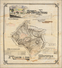
Detailed map of a section of the road from Guadalajara to the Pacific Coast in Nayarit.
The map shows the road from Tepic, southeast toward Guadalajara, published in Mexico City and signed by Ingeniero Director Adolfo Motta. The map is a section of the road that extended to the Port of San Blas, approximately 30 miles to the west.
The map is based upon a manuscript map by J.A. Motta, drawn in 1856, as described by Manuel Orozco y Berra, in Materials para una cartografie mexicana por el ingeniero Lic. Manuel Orozco y Berra, published in Mexico City by the Sociedad Mexicana Geografia y Estadistica.
Condition Description
Minor toning and soiling.

![[Austins Colony] Mexico & Guatemala](https://storage.googleapis.com/raremaps/img/small/94054.jpg)
![Mapa et tierra q[u]e yos pedro Vial taigo transitau en St. Tafee este dia 18 de Octubre de La ao 1787](https://storage.googleapis.com/raremaps/img/small/3645.jpg)