


|
||

|

|
|

|
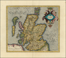
Attractive and detailed antique map of Southern Scotland, including the Highlands. One of the earliest obtainable maps of Scotland. Includes parts of the English borderlands and Northumberland, as well as Northern Ireland, bearing its Latin name Hibernia. Most text in Latin, though many places retain their Celtic names. Occasional English translations of major features. Portrays the Highlands as the diverse and densely populated country it was before the Clearances.
The detail on Scotland is extensive. Covers the country south of Torridon. Includes much of the Inner and Outer Hebrides, including Skye, Uist, Mull, and Islay. Includes abundant settlements, castles, lochs, mountain ranges, and rivers. An essential map for any collectors with an interest in Scotland.
Gerard Mercator is one of the most famous cartographers of all time. Mercator was born in Flanders and educated at the Catholic University in Leuven. After his graduation in 1532, Mercator worked with Gemma Frisius, a prominent mathematician, and Gaspar a Myrica, a goldsmith and engraver. Together, these men produced globes and scientific instruments, allowing Mercator to hone his skills.
With his wife, Barbara, Mercator had six children: Arnold, Emerentia, Dorothes, Bartholomeus, Rumold, and Catharina. In 1552, Mercator moved to Duisburg from Leuven, where he lived for the rest of his life. In 1564, he was appointed the official cosmographer to the court of Duke Wilhelm of Cleve.
Mercator’s most important contribution was the creation and popularization of a projection which now bears his name. On Mercator projection maps, all parallels and meridians are drawn at right angles to each other, with the distance between the parallels extending towards the poles. This allowed for accurate latitude and longitude calculation and also allowed navigational routes to be drawn using straight lines, a huge advantage for sailors as this allowed them to plot courses without constant recourse to adjusting compass readings.
Mercator’s other enduring contribution to cartography is the term “atlas”, which was first used to describe his collection of maps gathered in one volume. The Mercator atlas was published in 1595, a year after Mercator’s death, thanks to the work of his sons, particularly Rumold, and his grandsons.
![(Scotland) Novissima Regni Scotie Septentrionalis et Meridionalis Tabula, Divisae in Ducatus, Comitatus, Vice-Comitatus, Provincias Praefecturas, Dominia et Insulas. Auctore I. Covens et C. Mortier. [The Newest Map of the Northern and Southern Kingdom of Scotland, Divided into Duchies, Counties, Vice-Counties, Provinces, Prefectures, Dominions, and Islands. By J. Covens and C. Mortier.]](https://storage.googleapis.com/raremaps/img/small/93081.jpg)
![Johnson's Ireland [with] Johnson's Scotland](https://storage.googleapis.com/raremaps/img/small/78184.jpg)
![[Scotland] Scotia Parte Settentrionale . . . [and] Scotia Partie Meridionale . . .](https://storage.googleapis.com/raremaps/img/small/35543.jpg)