


|
||

|

|
|

|
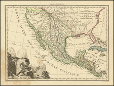
Scarce early reconnaissance map extending from Santa Fe and Fort Smith in the South to Ft. Laramie and the North Plate River in the south, complete with the Message From The President of the United States communication the report of Lieutenant Abert on the Upper Arkansas River in the Comanche country.
The map shows the length of the Santa Fe Trail from Independence to Santa Fe, via Bent's Fort.
The map shows a portion of the reconnaissance of John C. Fremont's final expedition. Fremont detached Topographical Officers Abert and Peck at Bent's Fort to survey the Canadian River Valley in anticipation of military conflict with Mexico over the impending annexation of Texas. Heading a thirty-five-man party, the two lieutenants explored the entire course of the Canadian River from its headwaters in northeastern New Mexico to its confluence with the Arkansas River in eastern Oklahoma.
Congress published Abert's official report in 1846 under the title Journal of Lieutenant J. W. Abert from Bent's Fort to St. Louis. Considered one of the best travel diaries by a soldier-engineer, it provided insightful observations about the region's natural history and the feared but little-known Kiowas and Comanches.
The accompanying map was likely compiled by Fremont's famous cartographer Charles Preuss. The map exhibits an amazing level of topographic detail, especially for the mountains of southern Wyoming, northern New Mexico, and Colorado where Long's and Pike's Peaks are named. The route of the expedition is plotted with dates marking the progression of the surveyors.
Wheat describes the map as reflecting the first accurate astronomical observations in what was mostly unknown country. It continues to be an important and highly desirable map of the southwestern frontier.
Report Description
75 pp. With 11 lithographed plates, 1 folding; 2 lithographed maps, 1 quite large and folding. Removed from larger volume. First Edition.
Scarce first edition of Abert's important report with a significant map. Wagner-Camp writes that
The report begins on August 9, 1845 at Bent's Fort. The party traveled south to the Raton Mountains and thence down the Canadian River, returning through the Creek Nation and arriving at Fort Gibson on October 21. Abert made the first astronomical observations in this unknown country, and his map is therefore of great importance.
The plates, made from watercolors by Abert, are quite striking, and include one of Bent's Fort. The large map shows the Platte and its north and south forks from the Missouri River to the Rockies, the Arkansas and Canadian Rivers, etc., with locations of Sioux, Pawnee, Arapahoe, Cheyenne, Comanche and Kiowa Indians.


![[ Colorado Atlas -- Presentation Copy ] Geological and Geographical Atlas of Colorado and Portions of Adjacent Territory](https://storage.googleapis.com/raremaps/img/small/101702.jpg)