|
||

|

|
|

|
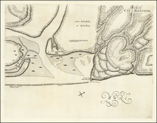
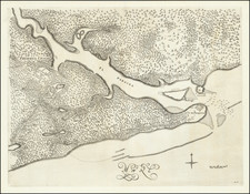
Guarani War-Era Manuscript Map on Vellum Showing the Disputed Regions between Brazil and Uruguay
Rare Spanish manuscript map, hand-drawn on vellum in the second half of the eighteenth century, depicting territory disputed by European imperial powers and the local peoples. Manuscript maps from this period are seldom located, and a richly embellished map on vellum like this is extremely rare.
The map title translates as "An Accurate Description of the South American settlements in St. Michael in the Province once called Tape, across the Uruguay River, and the adjacent Portuguese settlements and region."
This manuscript map shows the area known as the Banda Oriental, or as Tape to the Jesuits who ran missions in the area from the seventeenth to the mid-eighteenth century. This region was hotly contested throughout the eighteenth century by the Spanish, Portuguese, and Guarani and this map shows the fault lines of the conflict.
The map is east-oriented, as indicated by a sixteen-point compass rose in the upper right corner. The map is divided into separate estancias, which refer to areas, or “fields,” claimed by the Jesuit missions. The largest of these shown here is that of S. Miguel Grande, the same estancia mentioned in the title box in the lower right corner.
A key in the upper right explains the symbols for major and minor towns, those with or without a church, as well as destroyed towns. It also contains the scale. It reads:
EXPLICATIO SIGNORUM
- OPPIDA
- PAGI MAJORES
- PAGI MINORIS CUM SACELLIS SEU MAPALIA PASTORUM
- OPPIDA DESTRUCTA
SCALAM LEUCARUM 20 ADUNUM GRADUM IPSA DIVISIO GRADUUM PUDERET
The map also identifies the line demarcating the borders to which the Portuguese and Spanish agreed in 1753, three years after the Treaty of Madrid. At the right margin in the center is a note "Aqui llegaron A 1753 los Demarcado res de España y Portugal."
The map is filled with fascinating local details and notes. For example, at the top of the map, to the east, is a region noted as lands "occupada de los Portugese". Perhaps most curious is a group of skulls at the bottom right identified as "Acangue runa", several inches above the map title. Consultation with experts suggests that this was the site of a battle between the Spanish and the Guaraní during the campaigns of 1755-6. Nearby are three crosses at Cruzimboiapi, which may mark one of the largest battles of the conflict, the massacre at Caiboaté.
The map is meticulously drawn on vellum and it employs a pencil grid pattern. There seem to be contributions by at least two hands. The area depicted, and the level of detail used, points to a Spanish Jesuit as the maker, likely one eager to present and protect Jesuit claims. This was necessary because those missions were used as political pawns between Spain and Portugal in the mid-eighteenth century, a situation the Guaraní resisted.
Spanish-Portuguese Treaty of 1750
The Spanish-Portuguese treaty of 1750, known as the Treaty of Madrid, was signed by Ferdinand VI of Spain and John V of Portugal on January 13, 1750. It was meant to end the armed border dispute between the Spanish and Portuguese empires over the vicinity of the Uruguay River, an area known as the Banda Oriental (now comprising parts of Uruguay, Argentina and the state of Rio Grande do Sul, Brazil). The treaty established borders between the Spanish and Portuguese empires, recognizing much of what is today Brazil as Portuguese territory.
The Treaty of Madrid was based on the principles of Uti possidetis, ita possideatis; from Roman law, it means “he who owns by fact owns by right.” In effect, the Treaty recognized the de facto situation on the ground in South America and upheld natural geographic boundaries. The preamble states, “each party must stay with what it now holds,” and, “the boundaries of the two Domains... are the sources and courses of the most notable rivers and mountains.”
This authorized the Portuguese to retain the lands they had long occupied at the expense of the Spanish Empire. The treaty also stipulated that Spain would receive Colonia de Sacramento, while Portugal would gain the Misiones Orientales, seven independent Jesuit missions east of the upper Uruguay River: San Borja, San Nicolás, San Luis Gonzaga, San Lorenzo, San Miguel, San Juan Bautista y Santo Ángel. These missions are shown in a line on the far left, i.e. to the north, on this map.
The new boundary and Guaraní resistance
The treaty sought to follow geographic features in fixing the boundary: it moved westward from a point on the Atlantic coast south of Río Grande do Sul, then northward irregularly following parts of the Uruguay, Iguaçu, Paraná, Paraguay, Guapore, Madeira, and Javari Rivers. North of the Amazon, it ran from the middle Río Negro to the watershed between the Amazon and Orinoco basins and along the Guiana watershed to the Atlantic.
The Treaty of Madrid was significant because it substantially affected the modern boundaries of Brazil. However, it also called for the removal of the seven Jesuit missions of the Misiones Orientales west of the Uruguay River. Guaraní people who lived on the estancias were expected to relocate. The Guaraní, led by Sepé Tiaraju, rejected Portuguese rule and the order to relocate.
Instead, they fought for their lands, with the conflict erupting into the Guaraní War in 1754. The dispute simmered from 1754 to 1756, then broke out again in 1756 when a Spanish-Portuguese force sought to quell the remaining Guaraní fighters. Sepé Tiaraju was killed and, three days later, over 1,500 of his warriors were slain at the Battle of Caiboaté; only 4 Spanish and Portuguese soldiers were killed.
The disappointment of the Jesuits at surrendering their missions and the active resistance of the Guarani against forced their relocation contributed to the nullification of the Treaty of Madrid by the subsequent Treaty of El Pardo, signed by both empires in 1761. The Spanish claimed the land in the Treaty of San Ildefonso (1777), but the area was definitively ceded to Portugal in 1801 under the Treaty of Badajoz.
This map in context—a very rare find
The map was made within the preceding historical context. It was most likely made ca. 1755, during the Guaraní War and in a time when the Jesuits were begrudgingly relocating across the Uruguay River. It was probably made by a Jesuit wishing to definitively record the Jesuit claims in the region prior to the Treaty of Madrid. This map is an important historical document for Spanish and Portuguese colonial, Jesuit, and Uruguayan cartography. It represents a crucial step in the arduous journey of creating the modern borders of South America.
Additionally, the fact that it is on vellum makes it all the rarer. No similar vellum maps were found in public libraries, nor were printed copies of the map located.