|
||

|

|
|

|
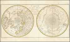
An interesting map on a north hemispheric projection, showing the regions that were actively been explored by the Russian, French and English.
Includes notes on Dutch, Portuguese and English discoveries near the North Pole.
The projection is based upon Phillipe Buache's work from the prior decade, and illustrates one view of the rapid changes along the NW Coast of America, NE Coast of Asia and Arctic Circle. In the 1740s, the France and England became acutely aware of the Russian voyages of discovery by Tchirikow, Bering and others into the NW Coast of America, especially following the return of JN De L'Isle from the Russian Court. Interest in what had until then been Unknown Regions intensified, and a number of important voyages of exploration were commenced in the second half of the 18th Century, culminating with the voyages of Cook, La Perouse, Vancouver, Dixon, Meares and others. The map shows the Sea of the West, badly distorted (and largely mythical) Alaskan Archipelago), several hopeful, in tentative routes from the Pacific to Hudson's Bay from the region between the Archipelago and the Sea of the West and one which extends from the Sea of the West. A very definite route from Japan to Portugal is shown. References to 17th Century explorations above the arctic are also noted. Perhaps the most salient feature of the map is the suggestion that there is no indication of any land masses near the poles.
The Gentleman’s Magazine was a British publication that helped to normalize the use of maps in support of articles and features. It was founded in 1731 by the prominent London publisher Edward Cave, a pioneer in periodical journalism. The magazine continued in print for nearly two centuries, shuttering production in 1922.
This was the publication which first used the word “magazine”, from the French for storehouse. Cave wanted to create a storehouse of knowledge and he employed some of London’s best writers to fill his pages: Samuel Johnson gained his first regular employment by writing for the Gentleman’s Magazine. Other famous contributors included Jonathan Swift.
The publication covered a broad range of topics, from literature to politics, and, from 1739, frequently used maps as illustrations. The first map they printed was a woodcut of Crimea; the second was a fold-out map of Ukraine by Emanuel Bowen. Maps were used to show battle lines, to chronicle voyages, and to educate about areas with which Britain traded. Certain geographers, like Thomas Jefferys, contributed several maps to the publication.
![Originalkarte zur Ubersicht des Standpunktes neuester Polarforschungen bis Ende September 1874. [with:] Provisiorische Skizze von Franz Joseph Land entdeckt von der 2. Oster.-ungar. Nordpolar-Expedition 1873 & 1874](https://storage.googleapis.com/raremaps/img/small/98481.jpg)
![[The Northern and Southern Skies] Hemisphaerii Borealis Coeli et Terrae Sphaerica Scenographia (and) Haemisphaerium Scenographicum Australe Coeli Stellati et Terrae](https://storage.googleapis.com/raremaps/img/small/78919.jpg)
![[ Pacific Northwest - Northwest Passage ] Limes Occidentis Quivira et Anian. 1597](https://storage.googleapis.com/raremaps/img/small/71207.jpg)