


|
||

|

|
|

|
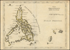
A Southern Luzon Rarity
Fine early chart of the southern part of the Island of Luzon, published by the Spanish Hydrographical Department.
The chart shows Manila and Cavite in the upper left portion of chart, extending south to show a large portion of the coast of Mindoro, the Ragay Gulf and Burias Island.
The chart is exceptionally detailed, with extensive soundings, topographical details and sailing directions.
The chart was prepared under the direction of Claudio Montero, who served as Admiral of the Spanish Royal Navy and oversaw the survey of the Philippines in the 1860s.
Rarity
The chart is extremely rare. We locate only an example in the British Library and 3 examples of the 1871 edition of the chart.
The Dirección de Hidrografía, or the Directorate of Hydrographic Works, was established in 1797. Its roots were in the Casa de Contratación, founded in 1503 in Sevilla, which housed all the charts of the Spanish Empire and oversaw the creation and maintenance of the padrón real, the official master chart. The Casa, now in Cadiz, was shuttered in 1790, but Spain still needed a hydrographic body. In response, the Dirección was created in 1797. One of its first projects was the publication of charts from the Malaspina Expedition (1789-1794). The Dirección oversaw not only publication, but also surveying. The Dirección was abolished in the early twentieth century, when their work was distributed to other organizations.
![[Philippine Islands, Taiwan, etc] Partie des Isles Philippines; Partie de la Chine; Partie de L'Ile Gilolo; Partie de L'Isle Borneo](https://storage.googleapis.com/raremaps/img/small/93579.jpg)