This item has been sold, but you can enter your email address to be notified if another example becomes available.


|
||

|

|
|

|
Stock# 56031
Description
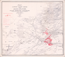
Rare separately published map of the area around Idaho Springs, Colorado, as surveyed by James Underhill.
The map extends from Idaho Springs to Lamartine and Downieville and North to Central City, identifying the locations of hundreds of mining claims.
The map identifies the Tunnel Lines and Territory of the Big Five, which includes:
- The Central and Georgetown Tunnels
- The entire water power of the Clera Creek and the Belman Mine
- The Miami Mines and Wilcox Tunnel
- The Edgar Consolidated Mines
![[Leadville / Alma District] London Mountain Gold Mining Company](https://storage.googleapis.com/raremaps/img/small/69724.jpg)
![The Mines of Colorado [with:] Map of Colorado Territory to accompany Hollisters](https://storage.googleapis.com/raremaps/img/small/100860.jpg)