|
||

|

|
|

|
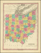
First State of Kilbourne's Rare Map of Ohio
Scarce early map of the State of Ohio, published in Columbus, Ohio in 1822 by John Kilbourne.
One of the earliest large format maps of Ohio. The state is hand colored by counties, with numerous townships laid out and named, although some counties are shown without townships. The map also provides a highly detailed treatment of the road system within the state.
In the north, the map reflects the old boundary which placed Toledo in Michigan Territory, but it does not specifically mention the dispute between Ohio and Michigan Territory, which is added in the second state of the map.
A number of early roads and place names do not appear on this map, but do appear for the first time on the second state of the map in 1822.
John Kilbourne
John Kilbourne published the first gazetteer of Ohio in Columbus in 1816. A second edition was published in the same year.
Kilbourne was born in Connecticut in 1787 and graduated from Vermont University, before moving to Ohio to join his uncle Colonel James Kilbourne in Worthington, Ohio, a town his uncle had laid out in 1804. Kilbourne became the principal of the Worthington Academy and taught geography, writing a Compendious System of Universal Geography Designed for Schools and Youths in General, published in Zanesville in 1813. In 1815, he published Columbia Geography, or A Description of the United States of America . . . , published in Chillicothe, Ohio, which included a Chapter on Ohio.
Shortly thereafter, Kilbourne left teaching and opened a book store on High Street in Columbus, "just a few doors from the State House," where in 1816, he published the first edition of his Ohio Gazetteer. In 1817, the first map appeared in the Gazetteer, a plat of the Town of Columbus, followed by a small woodcut map of Ohio in 1818. Beginning in 1821, the Gazetteer included a larger copper plate map of Ohio, entitled "A Map of Ohio. By John Kilbourne. Jany. 1821."
We find no discussion of Kilbourne's publication of this map, which seems to be a separately issued and perhaps enlarged edition of this 1821 map. Published on thicker paper, it seems clear that the present map was not intended to be folded into a book. As noted below, there seems to be evidence that the map was published in 1822, 1825 and 1826, with the 1822 and 1826 editions surviving in 1 example each and the 1825 previously unrecorded until the example we acquired in 2017 came to market.
Rarity
The map is extremely rare. It is not mentioned in Smith's The Mapping of Ohio, although Smith includes an extensive discussion of John Kilbourne as noted above.
OCLC lists the 1822 edition of the map (Library of Congress), but not the 1825 edition. The Ohio Historical Society also apparently holds a copy of the map dated 1826.
![Cleveland [on verso:] Map of Toledo](https://storage.googleapis.com/raremaps/img/small/98324.jpg)