|
||

|

|
|

|
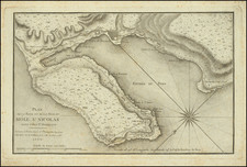
Exceptional Revolutionary-Era Manuscript Map Featuring Extensive Depiction of the Towns, Plantations, and Roads in Northwestern Haiti
This detailed eighteenth-century French manuscript map of the Nord-Ouest department covers the area between Môle-Saint-Nicolas and Jean Rabel. Manuscript maps from this century are rare, and such a comprehensive and tightly-focused map of an understudied region like this is particularly significant. Moreover, several details on the map point to a creation date of 1792-3, from just after the beginning of the Haitian Revolution.
The map is oriented with south at the top, with an outline of the south side of the peninsula paralleling the upper edge. The map includes topographic shading, emphasizing the mountainous interior of the peninsula. Plantations and settlements are marked with small squares, while roads are marked with dotted or solid double lines. Larger settlements, like Jean Rabel and Môle-Saint-Nicolas are indicated with a circle topped with a cross. Some shading along the northern coast is also evident and rivers receive especially close attention.
The map includes at least two hands, but probably three. The first (in tight black ink) focuses primarily on the area surrounding Jean Rabel, the second (in slightly looser brown ink), with a less refined touch, adds detail to the west around Môle-Saint-Nicolas. A third (in thin grey ink) is concerned with distances and relationships of plantations to the south of Jean Rabel. The brown ink follows the black ink, as the second hand has made what are obviously corrections and additions to the coastline, and elsewhere.
Thanks to expert consultation, we have dated the map to mid-1792 to mid-1793, just before the British invasion in September 1793. The inclusion of Bombarde, also known as Bombardopolis, indicates that the map was made post-1764, when the German settlers who founded Bombardopolis came to Saint Domingue. Place names and locations such as Camp General des Brigands, located in the Labarre Mountains, and Boucan Patriot, are unlikely to have been pre-revolutionary place names. This indicates a date of post-1791. However, the effects of the British invasion of Saint Dominque, which had its greatest success with the capture of Môle-Saint-Nicolas on September 22, 1793, point to a pre-late 1793 date.
The details on the map show familiarity with the region, and the minutiae include geographic, economic, and military features. For example, the ordinance at Plateforme have been added, due south of Môle-Saint-Nicolas on the opposite coast. Also, the sources of rivers are marked, for example at Pellier. Pelier was the name of a insurgent camp near Jean Rabel, but it is uncertain if this is the same settlement of Pellier, as marked on this map. The mapmaker is likely an individual with at least some formal training, or at least someone very familiar with contemporary map conventions, but more research is needed to unlock the many details included in what promises to be an important historical document.
Historical significance: the brigand camp and Northwest Haiti at the beginning of the Haitian Revolution
One of the most intriguing details on the map is the “camp gl des Brigand” at the far left of the map. While this could indicate a maroon (escaped slaves) outpost, it more likely references a camp of insurgents. Contemporaries used the word “brigands” to refer to black fighters during the Haitian Revolution. Even more interestingly, the camp is near a plantation marked Fouré. Joseph Fouré was an early slave leader in the region.
Although initially colonized by the Spanish, the French took over the western third of the island of Hispaniola in the early-eighteenth century. As in the rest of the Caribbean, they developed large-scale plantations worked by enslaved Africans, with coffee plantations in the interior and sugar on the northern plains. The slave regime in Saint Domingue is considered by scholars as one of the most extreme. Slave mortality was high and violence common; the French imported over 800,000 men and women to the colony, practically double the total number imported to North America. This economic system built on the forced labor of thousands made Saint Domingue the most lucrative colony in the world.
The area around Môle-Saint-Nicolas was part of the larger plantation system that covered much of the island, although the mountains also provided spaces for other ways of life, such as that of the maroons. One description of the area from a French officer just before the revolution began described the pretty little village of the highly-fortified Môle-Saint-Nicolas. It was, “a military post important for its situation, which has always been regarded as the main key of the colony, and which is considered impregnable when it is supplied and equipped with troops at times” (Delafosse de Rouville, 87).
On August 22, 1791, the slaves near Le Cap revolted against their colonial masters. The conflict quickly engulfed much of the colony, including the northwest region shown here. Jean Rabel and the mountains drawn on this map became strongholds for the insurgents. It must be remembered that the Haitian Revolution took place within the larger global phenomenon known as the Age of Revolutions; it was influenced by, and influenced in turn, other conflicts like the French Revolution. Many of the whites in the northwest region were split between Republicans and Royalists and many rebels invoked Louis XVI as a reason for their fighting.
By 1793, France was at war Spain and Britain, causing the other powers to set their eyes on Saint Domingue. They also had support from various factions within Saint Domingue; for example, there were pro-English factions in Bombarde and Jean Rabel. The Spanish and British knew of the strategic importance of Môle-Saint-Nicolas and, on September 22, 1793, the British Royal Navy took the important French naval base. However, the British restored slavery as they continued their invasion, a move that did not endear them to the black majority.
A complex revolution involving many stakeholders, the Haitian struggle would continue for over a decade. It outlasted the French Revolution, ending with the defeat of troops sent by Napoleon at the Battle of Vertieres on November 18, 1803. On January 1, 1804, Haiti became the first black republic in the world and the second independent country in the western hemisphere. This map is a source for more information about the early revolution in the northwest.
Historical significance: Prominent plantations, including that of Stanislas Pierre Foäche
Because of its relatively focused scope, the map provides a more detailed view of the plantation and farm structure of rural life in Saint-Domingue at the beginning of the Revolution. The main interest of the authors seems to have been to record the far-flung plantations and their names, as well as the roads that connected them; whether this was for trade, land speculation, or to mark claims at the onset of conflict we do not know, although it seems unlikely that it would have been used in a formal survey setting. While we have handled some important and detailed maps of Haiti from the eighteenth century and have conducted a survey of similar material in major institutional collections, this map's focus on the geography of plantations may be unique and historically significant.
For example, one of the plantations it includes is "Collette" near the "Savanne Collette". Pierre Collette was a farmer and officer who lived near Jean Rabel before the revolution. Nearby is "Etang Foache", or Foache’s Pond. Stanislas Pierre Foäche (1737-1806) was Collette’s superior and he owned a formidable plantation near Jean Rabel.
Foäche was a prominent citizen of Saint Domingue who worked as a slave trader and business agent (négociant) in Cap-Français. Foache hailed from a family of traders based in Le Havre, France; his father had started the business after service as a merchant captain. Both Stanislas and his brother, Martin-Pierre, worked in Saint-Domingue, taking in turns the running of the western operations of the family business. Adroit at business, Stanislas was one of the most well-known of the agents at work in the colony. He managed property and plantations for absentee landowners who preferred to stay in France. Like many other whites in Saint Domingue, Foäche was Protestant and had to pay a fee for his religious affiliation, as Saint Domingue was officially a Catholic colony.
As evidenced by the considerable size of the plantation near the pond, Foäche ran his property via slave labor; he owned 584 slaves who worked the 600-hectare sugar plantation. After the outbreak of hostilities, Foäche and his family moved to London in 1796. Similar biographies are likely tied to other plantations included on the map.
Historical significance: Bombardopolis
Another feature of note is the town of Bombarde, south of Môle-Saint-Nicolas. Bombardopolis was founded only in 1764 by German settlers. These Germans had fled a failed colony in French Guiana. They arrived at the same time as a group of Acadians displaced at the end of the Seven Years War. However, the local officials wished to keep the German separate from the Acadians, hence the creation of Bombarde. The town was named after a Mr. Bombarde, naturalist and businessman who was also the benefactor of the director of Môle-Saint-Nicolas, Mr. Fusée Aublet.
By the time this map was made, Bombarde was an important settlement as it provided foodstuffs and supplies to the important naval base of Môle-Saint-Nicolas. The town was small, however, affected by initial harsh conditions and a high mortality rate. In 1770, the German population was only 334 (down from 776 in 1766). In 1784, the town and surrounding parish of Bombarde had only 600 whites (French and Germans), 50 free people of color, and 900 slaves. In 1789, just before the revolution, the town housed two companies of militia, one of them German, totaling 160 men.
Rarity
We find no other eighteenth-century manuscript maps focused specifically on this region. This map tells important stories about the history of Saint Domingue as it entered a significant event of its own history and world history, the Haitian Revolution. Although usually left out of studies of the revolution, the area was actively involved in the conflict and maps like this can help to better understand not only the terrain, but its area’s economic, military, and social history as well. Saint Domingue manuscript maps from the eighteenth century are rare in and of themselves, but to find one in multiple hands with such a wealth of significant historical data makes this an exceptionally rare and contextually noteworthy object which deserves more careful study by experts.
![Cuba Insula [with] Hispaniola Insula [with] Insula Jamaica [with] Ins. S. Ioannis [with] I.S. Margareta Cum Confiniis](https://storage.googleapis.com/raremaps/img/small/95802.jpg)
![[Saint-Marc, Haiti] Plan de la Ville de St. Marc, dans l'Isle St. Domingue . . . 1785](https://storage.googleapis.com/raremaps/img/small/88259.jpg)