|
||

|

|
|

|
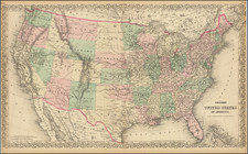
Includes the 36 Districts of the Republic of Texas!
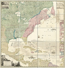
Marvelous large format map of the United States, which includes the names of both C.F. Weiland and H. Kiepert. The map includes a marvelous treatment of the Western Territories of the United States, including a massive Ober od Neu-Californien, Massive Indian Territory (extending to Canada), pre-dating the appearance of Nebraska Territory, Kansas, etc.
The map illustrates in color the German or Mainzer Colony (Deutsche Colonie des Mainzer Vereins), with a key identifying the location of the Districts of the Republic of Texas (36 are named).
The map locates the Route of the Escalante-Dominguez Expedition of 1776, here called "Routen der Jesuiten Escalante u Garcese 1775. The expedition was a Spanish journey of exploration conducted in 1776 by two Franciscan priests, Atanasio Domínguez and Silvestre Vélez de Escalante, to find an overland route from Santa Fe, New Mexico to their Roman Catholic mission in Monterey, California. Escalante, Dominguez, and Bernardo de Miera y Pacheco, acting as the expedition's cartographer, traveled with ten men from Santa Fe through many unexplored portions of the American West, including present-day western Colorado, Utah, and northern Arizona. Along part of the journey, they were aided by three indigenous guides of the Timpanogos tribe (Shoshone or Ute people).
Many other important roads through the Western part of the United States are shown, along with important early forts, such as Bent's Fort and Gant's Fort. in what would become Colorado Territory, Fort Washita on the Red River, Ft. Towson, Ft. Smith, Ft. Laramie, Ft. Pierre or Lookout, Ft. Clarke (Lewis & Clark, on the Missouri), and Fort Mandan.
This is the last edition of the map to show the unnamed lake below the Great Salt Lake (here called Salzsee Utah od Timpanagos), which includes a tentative river course flowing through the Sierra Nevada mountains and reaching to the Sacramento River. The American Fur Trading depot East of the Great Salt Lake is shown. In California, Sutter's New Helvetia is shown.
Massive Iowa Territory extends to Canada. This is the last edition of the map to pre-date the inclusion of Minnesota Territory. Wisconsin incorporates a part of Northern Minnesota, which is not yet named.
The map shows a number of early roads, most notably in the West. Captain Sutter's New Helvetia settlement (Colonie New Helvetia des Capt. Sutter) is noted, but pre-dating the discovery of gold. Many Indian tribes are named, more so than in most contemporary maps. The topography and hydrography are also quite well executed.
In Canada, a number of Hudson Bay Company Forts and Trading Houses are located.
The map is extremely rare, this being the first example we have seen in nearly 20 years. We also handed the 1847 map in 2011.
![The North Coast of the Gulf of Mexico from St. Marks to Galveston . . . 1844 . . . Additions to 1856, including the Surveys of Comr. Powell, Lt. Simmes & Profr. Coffin, U.S. Navy [and] St. Marks to Galveston. Sheet II. . . . 1845. Additions to 1851 . . . .](https://storage.googleapis.com/raremaps/img/small/89497.jpg)