|
||

|

|
|

|
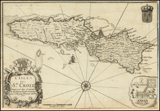
An Important Early Map of St. Croix -- With an Early Expedition Added in Manuscript!
Rare separately published sea chart of St. Croix, first published by the British Admiralty in 1858.
The present example is corrected to May 1863.
The chart presents a fine large image of St. Croix, perhaps the largest separate sea chart of the island to date, along with a large inset of the Christianstaed Harbor and six profile views of approaches to the island from the north. In the interior of the island, a grid-like road system is present, with dozens of places located including little symbols for windmills, likely noting Sugar Mills located on some of the named plantations.
The chart provides topographical details and elevations, and also shows lighthouses, towns, anchorages and other places of interest.
Early Annotations
The present example includes the meticulous addition of a route traveled in the interior of St. Croix by an early planner. Given the timing and circuitous nature of the lines and black boxes, it is possible these are early telegraph lines. A second route in red is shown, remaining closer to Christianstaed.
Rarity
The map is extremely rare. OCLC locates no other examples and we were not able to locate another example at auction or in dealer catalog records going back more than 30 years.
The British Admiralty has produced nautical charts since 1795 under the auspices of the United Kingdom Hydrographic Office (HO). Its main task was to provide the Royal Navy with navigational products and service, but since 1821 it has also sold charts to the public.
In 1795, King George III appointed Alexander Dalrymple, a pedantic geographer, to consolidate, catalogue, and improve the Royal Navy’s charts. He produced the first chart as the Hydrographer to the Admiralty in 1802. Dalrymple, known for his sticky personality, served until his death in 1808, when he was succeeded by Captain Thomas Hurd. The HO has been run by naval officers ever since.
Hurd professionalized the office and increased its efficiency. He was succeeded by the Arctic explorer Captain William Parry in 1823. By 1825, the HO was offering over seven hundred charts and views for sale. Under Parry, the HO also began to participate in exploratory expeditions. The first was a joint French-Spanish-British trip to the South Atlantic, a voyage organized in part by the Royal Society of London.
In 1829, Rear-Admiral Sir Francis Beaufort was appointed Hydrographer Royal. Under his management, the HO introduced the wind force scale named for him, as well as began issuing official tide tables (1833). It was under Beaufort that HMS Beagle completed several surveying missions, including its most famous voyage commanded by Captain FitzRoy with Charles Darwin onboard. When Beaufort retired in 1855, the HO had nearly two thousand charts in its catalog.
Later in the nineteenth century, the HO supported the Challenger expedition, which is credited with helping to found the discipline of oceanography. The HO participated in the International Meridian Conference which decided on the Greenwich Meridian as the Prime Meridian. Regulation and standardization of oceanic and navigational measures continued into the twentieth century, with the HO participating at the first International Hydrographic Organization meeting in 1921.
During World War II, the HO chart making facility moved to Taunton, the first purpose-built building it ever inhabited. In 1953, the first purpose-built survey ship went to sea, the HMS Vidal. Today, there is an entire class of survey vessels that make up the Royal Navy’s Hydrographic Squadron. The HO began to computerize their charts in the late 1960s and early 1970s. In 1968, the compilation staff also came to Taunton, and the HO continues to work from there today.
![Amer. Sep. No. 69. Porto-Rico [and the Virgin Islands]](https://storage.googleapis.com/raremaps/img/small/42102.jpg)
![Porto Rico and Virgin Islands [with] Haiti, Hispaniola or St. Domingo](https://storage.googleapis.com/raremaps/img/small/78402.jpg)
![Carte Reduite des Isles Antilles Dressee au Depost des Cartes et Plans de la Marine… [Large Inset of Virgin Islands]](https://storage.googleapis.com/raremaps/img/small/68206.jpg)