This item has been sold, but you can enter your email address to be notified if another example becomes available.


|
||

|

|
|

|
Stock# 55934
Description
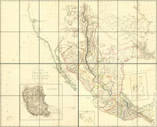
Detailed map of the area from Fort Pierre, South Dakota on the Missouri River to the Rocky Mountains, published as part of the Pacific Railroad Surveys.
The map shows the western section of one of the routes surveyed from St. Paul westward, as a possible route for the transcontinental railroad.
The route of Isaac Stevens party and Lieutenant Grover's detachment are shown, along with the daily camps.
Condition Description
A number of repaired fold splits.

![Carte Du Canada ou de la Nouvelle France et des Decouvertes qui y ont ete faites . . . [Map of Canada or New France and the Discoveries Made Therein . . .]](https://storage.googleapis.com/raremaps/img/small/94450.jpg)