


|
||

|

|
|

|
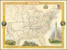
Rare late edition of this outstanding map of the United States following the American Civil War.
Earlier editions of this map were issued while Oregon was a Territory and the Republic of Texas dominated the southwest. Remnants of the earlier edition are still prevalent, as Oregon Territory, Upper California and an oversized Kansas are still titled, the contemporary borders have been added.
The current regions of interest are the mis-projected Idaho-Wyoming-Montana border .
In addition to contemporary borders, the map notes many important treaty boundaries and proposals, including the 1848 Boundary prior to the Gadsden Treaty, the Line of the Treaty of Florida which created the boundary between New Spain and Oregon Territory on February 22, 1819 and January 12, 1828, the proposed boundary between Mexico and the US proposed by the Americans in 1835, the US-Canada proposed border of October 20, 1818, etc.
The detail in the Northwest is especially impressive, with many Forts and other landmarks appearing which are not usually present on American maps of the same period. The roads in the West and Northwest are also well delineated.
Texas is oddly misshapen along the Rio Grande.
James Wyld Sr. (1790-1836) was a British cartographer and one of Europe’s leading mapmakers. He made many contributions to cartography, including the introduction of lithography into map printing in 1812.
William Faden, another celebrated cartographer, passed down his mapmaking business to Wyld in 1823. The quality and quantity of Faden’s maps, combined with Wyld’s considerable skill, brought Wyld great prestige.
Wyld was named geographer to Kings George IV and William IV, as well as HRH the Duke of York. In 1825, he was elected an Associate of the Institution of Civil Engineers. He was one of the founding members of the Royal Geographical Society in 1830. Also in 1830, his son, James Wyld Jr., took over his publishing house. Wyld Sr. died of overwork on October 14, 1836.
James Wyld Jr. (1812-87) was a renowned cartographer in his own right and he successfully carried on his father’s business. He gained the title of Geographer to the Queen and H.R.H. Prince Albert. Punch (1850) described him in humorous cartographic terms, “If Mr. Wyld’s brain should be ever discovered (we will be bound he has a Map of it inside his hat), we should like to have a peep at it, for we have a suspicion that the two hemispheres must be printed, varnished, and glazed, exactly like a pair of globes.”
![Map of the United States And Territories, Together with Canada &c. [Shows Massive Idaho Territory]](https://storage.googleapis.com/raremaps/img/small/100353.jpg)
![Trails: [1595-1945]: Land, Sea, and Air of The American Adventure Series](https://storage.googleapis.com/raremaps/img/small/70672.jpg)