|
||

|

|
|

|
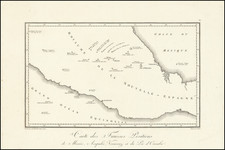
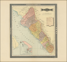
The Southernmost Portion of the Camino Real de Tierra Adentro (Road to Santa Fe).
Rare map showing the southernmost portion of the Camino Real, proceeding north from the outskirts of Mexico City toward Santa Fe.
The map is oriented with east at the top and tracks the various towns, haciendas, and topographical features along the route. The haciendas and settlements are shown in minute detail, making the map of use to historians wishing to understand the layout of pueblos and other multi-building sites. One detail of note is at the southern (right) side of the map. A small building marked “peage” is placed next to the road. This is where travelers would have to pay the peaje, or toll, to continue north.
This map was published as part of the new Ministerio de Fomento, which was founded in 1853 to oversee public works and development projects and was headed by Manuel Siliceo. When this map was issued in ca. 1857, Siliceo was in active opposition to the new Constitution of 1857 and would soon help draft the Plan of Tacubaya and play a prominent role in the Reform Wars (1858-1860).
This is apparently one of—if not the—earliest attempt to document the route by the Mexican Government and coincides with a more general increase in government mapping in the mid-nineteenth century.
The Camino Real de Tierra Adentro
The Camino Real de Tierra Adentro, also known as the Camino a Santa Fe, was an 1,800-mile-long commercial route that ran from Mexico City to the city of Santa Fe, New Mexico. It was in constant use between the mid-sixteenth century and the nineteenth centuries.
In the central portion of the route, important silver deposits were found; the portion of the road that connected Mexico City with these deposits in Zacatecas was called the Ruta de la Plata, or the Camino de la Plata. However, all of the Camino Real de Tierra Adentro is sometimes also referred to by this name, as the entire route had access to multiple mining areas and cities in New Spain.
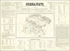
The route started from Mexico City and passed through important cities such as Queretaro, Guanajuato, Aguascalientes, San Luis Potosi, Zacatecas, Durango, Chihuahua, and Ciudad Juárez. It extended to El Paso in Texas and Las Cruces and Albuquerque in New Mexico before arriving in Santa Fe.
This road was used to transport silver extracted from the mines of Zacatecas, Guanajuato and San Luis Potosí, as well as mercury imported from Europe. It also allowed for the development of a travel economy based on hostels, inns and haciendas.
Today, the Camino still has a presence thanks to its important heritage forged over three centuries. There are archives, works of religious and civil art, musical events and festivities, culinary culture and oral traditions all centered around the Camino.
Cuautitlán
The largest settlement shown on this map is Cuautitlán, a city in the state of Mexico, just north of the Distrito Federal within the Greater Mexico City area. The smaller settlement has been largely engulfed by the megacity, making the two synonymous today. The name comes from Nahuatl and means “between the trees.” Originally, the town was a Chichimeca settlement, founded in the fourteenth century. It was then overseen by the Tlacopan and then conquered by the Aztecs, hence the Nahuatl name.
![(Second French Intervention in Mexico - Manuscript Map) Michoacan [and parts of Guanajuato and the Bajío region of Mexico]](https://storage.googleapis.com/raremaps/img/small/86018.jpg)