


|
||

|

|
|

|
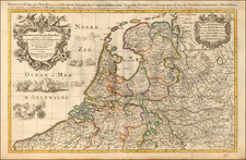
Detailed map centered on the Utrecht region, published in Amsterdam by Pierre Mortier circa 1700.
Includes a decorative title and scale cartouche.
The map features towns such as Yselstein, Woerde, Montfoort, Kulenborg, etc. and includes roads and waterways. Centered on Utrecht, the map reaches Amerfoort, Tiel, Gorckum, Goude and Amsterdam.
Pierre, or Pieter, Mortier (1661-1711) was a Dutch engraver, son of a French refugee. He was born in Leiden. In 1690 he was granted a privilege to publish French maps in Dutch lands. In 1693 he released the first and accompanying volume of the Neptune Francois. The third followed in 1700. His son, Cornelis (1699-1783), would partner with Johannes Covens I, creating one of the most important map publishing companies of the eighteenth century.
![[Composite Lafreri-style Atlas of Battle Plans and Fortifications]](https://storage.googleapis.com/raremaps/img/small/92702.jpg)
![[ Maastricht ] Traiectum ad Mosam](https://storage.googleapis.com/raremaps/img/small/96874.jpg)
![[Low Countries ] Belgium Foederatum emendate auctum et novissime editum](https://storage.googleapis.com/raremaps/img/small/98432.jpg)