This item has been sold, but you can enter your email address to be notified if another example becomes available.


|
||

|

|
|

|
Stock# 55801
Description
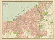
Fine early map of Cleveland, published by J.S. Morse and lithographed by W.J. Morgan & Co. of Cleveland, Ohio.
The map shows Cleveland, centered around the Cayahoga River. The city is divided by wards, with street railways shown in red and regional railroads in black. A circular patter shows distances from tthe center of town in the First Ward, at the intersection of Euclid, Woodland, Ontario and Broadway.
A list at the bottom left show the Fire Alarm Telegraph number for several hundred buildings. To the right are lists identifying Auditoriums, Cemeteries, Fire Engine Houses, Hospitals, Police Stations and Hook and Ladder Companies. At the far right is a street index.
Condition Description
Folding map with original covers. Map detached from covers. Minor loss at fold intersections.
![Ohio: Transportation Center of America [on verso:] travel Ohio For Fun It's Great Outdoors](https://storage.googleapis.com/raremaps/img/small/96001.jpg)
![[Indiana, Ohio, Kentucky, and Virginia] Amer. Sep. No. 50. Partie des États Unis](https://storage.googleapis.com/raremaps/img/small/93543.jpg)
![(Ohio Western Reserve) [1825 Connecticut Western Reserve Land Agreement, between Joshua Stow and Abijah S. Barnum, with Manuscript Plat Map]](https://storage.googleapis.com/raremaps/img/small/82629.jpg)