|
||

|

|
|

|
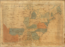
Fredonia in Texas!
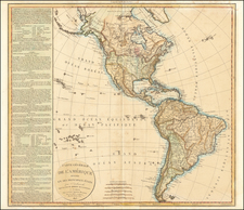
Fascinating Greek Map of the Americas, Published in Athens During the American Civil War.
Lithographed folding map of the Americas entirely in Greek. Published in Athens by Lazaridou in 1861, during the American Civil War.
The map features interesting cartographic eccentricities:
- In Ohio, the authors have placed "Philadelphia" and a river to the flowing northward to the east of it, and having been convinced of their error, they crossed both out, rather than erasing them from the matrix.
- The Missouri River is mislabeled the Mississippi River.
- The Texan Gulf Coast is labeled "Fredonia". A late example of that appellation.
Elsewhere the toponyms adhere more closely to the conventions of the time:
- Alaska is Russian America.
- In the American West, there is New California, New Mexico, and Oregon. And in California, Monterey, San Francisco, and Catalina are shown, among other places.
- In South America, New Grenada, Ecuador, Peru, Brazil, La Plata, Chili and other countries are shown.
- Canada is labeled "New Britain".
Fredonia
The map depicts the short lived "Republic of Fredonia," a reference to the Fredonia Rebellion, the first attempt to create a separate independent Republic in Texas. The Fredonian Rebellion (December 21, 1826 - January 31, 1827) was the first attempt by Anglo settlers in Texas to secede from Mexico. Led by empresario Haden Edwards, a group of Texas settlers declared independence from Mexican Texas and created the Republic of Fredonia near Nacogdoches, Texas. The republic encompassed land the Mexican government had granted to Edwards in 1825 and included areas that had been previously settled. Edwards's actions soon alienated these established residents, and the increasing hostilities between them and settlers recruited by Edwards led the Mexican government to revoke Edwards's contract.
In late November 1826, a group of Edwards's supporters took control of the region by arresting and removing from office several municipality officials affiliated with the established residents. A month later, the Edwards supporters declared their independence from Mexico. Although the nearby Cherokee tribe initially signed a treaty to support the new republic, overtures from Mexican authorities and respected empresario Stephen F. Austin convinced tribal leaders to repudiate the rebellion. On January 31, 1827, a force of over 100 Mexican soldiers and 250 militiamen from Austin's colony marched into Nacogdoches to restore order.
The rebellion led Mexican President Guadalupe Victoria to increase the military presence in the area. As a result, several hostile tribes in the area halted their raids on settlements and agreed to a peace treaty. The Comanche abided by this treaty for many years. Fearing that through the rebellion the United States hoped to gain control of Texas, the Mexican government severely curtailed immigration to Texas. This new immigration law was bitterly opposed by colonists and caused increasing dissatisfaction with Mexican rule. Some historians consider the Fredonian Rebellion to be the beginning of the Texas Revolution.
Rarity
The map is apparently very rare. We found no other examples of the map at auction or in dealer catalogs.
![[ United States ] Etats-Unis de l'Amerique](https://storage.googleapis.com/raremaps/img/small/98821.jpg)
![[French America and the Triangular Trade] L'Amérique Françoise Où son Décrites La France Nouvelle, La France Insulaire, La France Equinoctiale, et autre pais Par P. Du Val d'Abbeville Geographe du Roy . . .](https://storage.googleapis.com/raremaps/img/small/91968.jpg)