


|
||

|

|
|

|
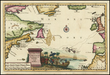
First State of the Primary French Sea Chart of the North Atlantic of the Mid-Eighteenth Century
Fine example of this rare general sea chart of the North Atlantic Ocean, published by the French hydrographic authority, the Depot de la Marine, in 1738.
The chart covers the coastline of North America from Newfoundland and the Grand Banks in the north to the mouth of the Amazon River in the south. To the east, the chart shows the coast of Europe and Africa from Amsterdam to the Benin River. It comprises an overview of the waters regularly traversed by European ships in the first half of the eighteenth century and also shows major areas then under French imperial control.
A good portion of each of the continents is included with major port cities named. Intended to aid navigation, the toponyms cluster around the coastlines, with the interiors left largely blank. Shoals, sandbars, and other obstructions are labeled throughout. The chart is centered on a large compass rose with radiating rhumb lines.
Imperial divisions
Although the chart does not include political divisions, it nevertheless reveals some of the imperial geography of the Atlantic in the mid-eighteenth century. For example, the coast of North America is labeled with several of the British colonies, including “Caroline,” Viriginie,” and “Pensilvanie.” The entire area of New England is labeled “Nouv: Angleterre,” rather than dividing it into the several colonies that inhabited the area.
To the south, Florida is not labeled as such, but its peninsular shape—here ending in a dense archipelago—is recognizable all the same. In 1738, when this chart debuted, Florida was a Spanish outpost. The Spaniards had first come to the area in 1513, led by the conquistador Juan Ponce de León. In 1564, Fort Caroline was founded by René Goulaine de Laudonniére as a refuge for French Huguenots. The fort was later attacked by the Spanish, while the French and British routinely sacked Spanish settlements.
When this chart was made, Spain was nominally in control of the peninsula, although it was surrounded by the British to the north, in Georgia, and to the west, by New France, and faced rebellion within from local indigenous peoples. A quarter century after the chart was made, in 1763, Spain lost Florida in exchange for the return of Havana, Cuba, which had been taken during the Seven Years’ War. The land was returned to Spain at the close of the American Revolution, but Spain then ceded the land to the United States in 1821.
The chart also shows the powerhouses of the French empire in the eighteenth century, although this particular imperial geography was on the verge of changing when the chart was released. West of New England is the large label, “Nouvelle France.” Along with Newfoundland, this was the edge of the expansive French claims which extended far into the interior of the continent. To the south is Saint Domingue, the richest of the Caribbean islands. France also had numerous trade entrepots throughout the African coast.
Just as Florida switched hands several times, so too did the control of the French colonies. New France was lost when the British defeated France in the Seven Years’ War, while Saint Domingue witnessed the Haitian Revolution, the world’s most successful slave rebellion, at the turn of the nineteenth century. However, and despite a brief period of abolition between 1794 and 1802, slavery continued to be practiced in the French Empire until 1848. At the time this chart was made, African peoples were still being transported across the very waters shown here and placed in bondage to labor in the plantations of the Caribbean and New France.
Production and rarity
The chart was engraved in Paris by Guillaume Dhueulland (1700-1770) and issued by order of Jean-Frédéric Phélypeaux Maurepas (Comte de, 1701-1781). Maurepas was a trained statesman and served as Ministre de la Marine to Louis XV from 1723 to 1749. Under his watch, Maurepas rejuvenated and strengthened the French Navy. One of his particular goals was to improve navigation and he achieved this by overseeing and expanding the Dépôt des cartes et plans de la Marine, who made this chart.
This is the first edition of what would become the standard French sea chart of the Atlantic for more than a decade, going through several later editions. This first state of the chart is quite scarce on the market. We locate only one auction and no dealer records in the past thirty years.
The Dépôt de la Marine, known more formally as the Dépôt des cartes et plans de la Marine, was the central charting institution of France. The centralization of hydrography in France began in earnest when Jean-Baptiste Colbert became First Minister of France in 1661. Under his watch, the first Royal School of Hydrography began operating, as did the first survey of France’s coasts (1670-1689). In 1680, Colbert consolidated various collections of charts and memoirs into a single assemblage, forming the core of sources for what would become the Dépôt.
The Dépôt itself began as the central deposit of charts for the French Navy. In 1720, the Navy consolidated its collection with those government materials covering the colonies, creating a single large repository of navigation. By 1737, the Dépôt was creating its own original charts and, from 1750, they participated in scientific expeditions to determine the accurate calculation of longitude.
In 1773, the Dépôt received a monopoly over the composition, production, and distribution of navigational materials, solidifying their place as the main producer of geographic knowledge in France. Dépôt-approved charts were distributed to official warehouses in port cities and sold by authorized merchants. The charts were of the highest quality, as many of France’s premier mapmakers worked at the Dépôt in the eighteenth century, including Philippe Bauche, Jacques-Nicolas Bellin, Rigobert Bonne, Jean Nicolas Buache, and Charles-François Beautemps-Beaupré.
The Dépôt continued to operate until 1886, when it became the Naval Hydrographic Service. In 1971, it changed names again, this time to the Naval and Oceanographic Service (SHOM). Although its name has changed, its purpose is largely the same, to provide high quality cartographic and scientific information to the France’s Navy and merchant marine.
![[Azores & Madera] Carta particolare dell' Isole d'Asores con l'Isola di Madera . . .](https://storage.googleapis.com/raremaps/img/small/58784.jpg)

![[St. Helena] Vera effigies et delineatio Insulae Ascenscio nuncupatae, sitae in altitudine 8 graduum, ad austrum lineae aequinoctialis](https://storage.googleapis.com/raremaps/img/small/78963.jpg)