|
||

|

|
|

|
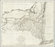
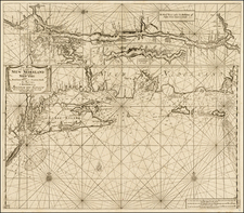
By far the finest 18th -- century map of New York State, compiled by two German geographers who never visited America.
This remarkable map depicts New York in its entirety as well as border areas of Canada, Vermont, Massachusetts, Connecticut, New Jersey and Pennsylvania. The topographic detail is fairly strong for a map of this scale, with much attention given to elevations in the Hudson River Valley and waterways in the central part of the state. The mapmakers use standardized line forms to differentiate state boundaries, county lines, township boundaries, and major roads. Counties are picked out in outline and wash color, including Chenango, Oneida and Rockland Counties, established in 1798, but not Cayuga or Essex, established in 1799, the year the map was published. Though the predominant language on the map is German, the legends are bilingual and the prime meridian set at Washington, D.C., suggesting that it was intended for both German and American audiences.
The map is of particular interest for so clearly revealing the distinct processes by which different parts of the state developed. Because of its access to New York and strategic value, the Hudson River-Lake George-Lake Champlain Valley was mapped and settled in the 17th -18th centuries, to a great extent in huge manors granted first to Dutch patroons and later to powerful and connected members of the British military and administrative class. With the exception of small settlements along the Mohawk, areas further west were distributed in the late 18th and early 19th centuries, either in small parcels to Revolutionary War veterans in the case of Onondaga County or in huge blocks to private investors. Many such areas are shown divided into roughly 6-mile square townships, though Morris’s Purchase west of the Genesee—soon sold on to the Holland Land Company—is for some reason not indicated. The Adirondacks—labeled
as both Herkimer County and “McCom’s Purchase”—are minimally surveyed and appear all-but uninhabited.
Earlier maps by Montresor and Sauthier had depicted eastern New York at a very large scale and in great detail. Sotzmann’s map is however by far the best 18th-century map of the state as a whole, though it would be surpassed in 1802 by Simeon de Witt’s Map of the State of New York.
Ebeling, Sotzmann and the Erdbeschreibung
This map was intended for a planned atlas to accompany Christoph Daniel Ebeling’s Erdbeschreibung und Geschichte von Amerika, a magisterial study of the geography and history of the new United States. Ebeling (1741-1817) was a Hamburg academic with a general interest in free states, which interest lead him to a decades-long fascination with America and ultimately to conceive the Erdbeschreibung project. To this end, he carried on a voluminous correspondence with leading Americans, who supplied him among other things with the most up-to-date American maps available. His map library eventually made its way back to America, where it was purchased by a Boston collector and eventually became the nucleus of the Harvard Map Collection.
To produce the maps Ebeling commissioned Daniel Friedrich Sotzmann (1754-1840), Geographer of the Berlin Academy. Ristow, summarizing the assessment of scholar Wolfgang Scharfe, describes Sotzmann as one “of the most distinguished cartographers in the German-speaking countries in the early years of the nineteenth century” (p. 177). The atlas was to contain 18 plates, including 16 of the individual states. Unfortunately, neither the narrative nor the atlas were fully realized, perhaps because of Ebeling’s advancing years and (in his view) a lack of sufficiently accurate source material, particularly for the southern states and the newly-admitted states west of the Appalachians. In all, seven volumes of the Erdbeschreibung were issued between 1793 and 1816, while ten maps were completed: [I?] Vermont (though numbered XVI), 1796; II. New Hampshire, 1796; III. Massachusetts, undated; IV. Maine, 1798; V. Rhode Island,
1797; VI. Connecticut, 1796; VII. New York, 1799; VIII. New Jersey, 1797; IX. Pennsylvania, 1797; X. Maryland and Delaware, 1797. (According to William Coolidge Lane, in Letters of Christoph Daniel Ebeling…: “Apparently Virginia was never engraved. Later letters show that Ebeling found difficulty in getting the material.”) With the odd exceptions of the New Jersey and Rhode Island maps, all of these maps are now scarce, while some (such as Maryland) are extremely rare, and few institutions possess full sets.
Brown and Ristow differ considerably on Ebeling and Sotzmann’s respective roles in compiling the state maps, with Brown arguing for Ebeling as the prime mover and Ristow favoring Sotzmann. Whatever their relative contributions, they developed the state maps by sifting, compiling and reconciling the source maps in Ebeling’s collection with a highly critical eye. The result is a set of maps that, while in some sense derivative of American sources, were for a time—and in some cases a long time—the best available of their kind.
Sources for the New York map
Sotzmann’s collaborator Christoph Daniel Ebeling maintained a correspondence with leading lights of American science, who provided the source maps, both printed and manuscript, that the Germans sifted, compiled and reconciled with a highly critical eye. Regarding their sources for this map of New York State, we are fortunate to have the following gem, buried in an October 4, 1796 letter from Ebeling to Noah Webster, cited by Ralph Brown:
As to New York I am very much at a loss, as I have not but Gathier’s (?) [i.e., Sauthier’s], Pownall’s, Ratzer’s (?) and one sheet of De Witt’s. If there is published any more, I should be extremely rejoiced in getting it. Carey’s map I have also, but it is very defective.(“Early Maps of the United States: The Ebeling-Sotzmann Maps of the Northern Seaboard States,” p. 477. The text in square brackets is ours.)
The maps in question are probably Claude Joseph Sauthier’s Chorographical Map of the Province of New York (1779), Thomas Pownall’s revision of Samuel Holland’s The provinces of New York and New Jersey; with part of Pensilvania, and the province of Quebec (1776), Bernard Ratzer’s Plan of the City of New York (1776) and/or The Province of New Jersey, Divided into East and West (1777), Simeon de Witt’s 1st Sheet of De Witt’s Map of New-York (ca. 1793), and Matthew Carey’s State of New York (1795).
In his article, Brown cites as Ebeling and Sotzmann’s “principal bases” only “Simeon De Witt and Abraham Bradley (1796) (p. 474). The latter must be Abraham Bradley’s Map of the United States Exhibiting Post Roads and Distances, by far the most accurate map of the country produced in the 1790s.
However, Brown is largely incorrect: despite Ebeling’s dismissiveness of Carey, it appears that the latter’s map was the principal base for Sotzmann’s, both graphically and cartographically. Indeed, in western New York, Sotzmann follows Carey closely, with only minor changes. Throughout the rest of the map, Ebeling and Sotzmann have gone to great lengths to improve on Carey’s model.
Clearly, they did rely heavily on De Witt’s work. He was the essential source for New York mapping in the 1790s, and the Ebeling-Sotzmann map’s treatment of central New York is very similar to that on the 1st Sheet of De Witt’s Map of New-York. As for Bradley, however, there is at best only a general resemblance, as the scale on his map is far too small to provide the level of detail required by the Germans. Indeed, while Ebeling and Sotzmann might have been expected to rely on Bradley above all for their depiction of New York’s roads, in this respect the two maps bear almost no resemblance.
In truth, given their critical approach to map compilation and the state of the mapping of New York in the 1790s, it would be surprising if we were able to identify just one or two sources for their work. Most likely they relied heavily on de Witt’s 1st Sheet for the central part of the state but drew on a large range of manuscript and printed sources for the rest. Whatever their exact mix of sources was for the map, the project caused them considerable heartache:
[The map] of New York coasts [sic] me a great deal of trouble and many expenses to the Editor as the erection of new Counties obliged us to engrave a considerable part answer. (Ebling to William Bentley, Sept. 7, 1799, cited in Ristow, p. 171).
The relationship between Carey’s 1795 Atlas and the Sotzmann-Ebeling project requires closer study. Carey’s atlas was published in the same year that Ebeling’s was announced, and as Carey’s was the first national atlas of the United States, it established the framework for such a book. These points lead us to ask: to what extent was the Ebeling-Sotzmann project a conscious attempt to improve upon Carey? And, was the project cut short in part by Ebeling’s inability to improve upon Carey’s southern and western maps? Related to this last point, we are aware of at least one instance in which an early owner had 10 Sotzmann maps bound with 10 Carey maps to create a complete picture of the geography of the United States.
In summary, a fine and rare 18th-century map of New York, worthy of further study.