


|
||

|

|
|

|
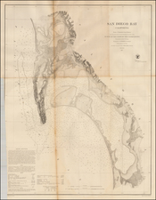
Detailed geological survey map from the WW II Period.
The map extends northwest to just beyond the Scripps Pier and the La Jolla Farms area, east to the Navy Field Landing Field and Mooring Mast, South to Ocean Beach and University Heights.
Excellent detail in La Jolla, including the Caves, Goldfish point, the Cove, Point La Jolla, Rocky Pt. Sea Rock and Whale View Pt. Hidden Valley and Ardath Road are shown as dirt roads. La Jolla Mesa, La Jolla Hermosa, Bird Rock and False Point are also named.
La Jolla High School is shown, the final stop on the San Diego Electric Railway, which extends south through Pacific Beach and Mission Beach, before crossing into Ocean Beach and heading inland to Point Loma and downtown San Diego.
In Pacific Beach, PB Jr. High School and PB Elementary are named, as is Crystal Pier and the Brown Military Academy. Crown Point is named, but to the south, the dredging work that creates the south part of the Mission Bay has not commenced.
Interesting early features include:
- Rosedale Landing Field
- Pacific Beach Siding off the old railroad line
- Ladrillo
- An Airway Beacon in Claremont
The map shows the following communities:
- Morena
- Bayside Village
- Overlook
- Crown Point
- Selwyn
![(San Diego) [Downtown San Diego Embarcadero and Seaport Village area south of Market Street]](https://storage.googleapis.com/raremaps/img/small/96681.jpg)
![[ Oceanside / Camp Pendleton ] Map of Swamp Land Survey No. 1 Location No. 908 Situated in San Diego County, Cal. . . . Surveyed under instructions of Hon. M.J. Wright, Surveyor General of California, by S.L. Ward, County Surveyor of San Diego County on the 8th, 9th 10th & 11th of October, 1900.](https://storage.googleapis.com/raremaps/img/small/96547.jpg)
![[ Naval Base San Diego / California Southern Railroad ] Referee's Map of Pueblo Lot 1166 in City of San Diego . . . .](https://storage.googleapis.com/raremaps/img/small/96386.jpg)
![(San Diego Water Management) Map of the Dam and Reservoir Site on the Sweetwater River, San Diego County, California belonging to San Diego Land & Town Co. March 1887 [Jamacha Rancho]](https://storage.googleapis.com/raremaps/img/small/97272.jpg)