


|
||

|

|
|

|
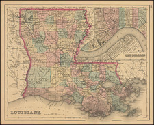
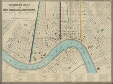
An Early New Orleans Map Published in New Orleans
Highly detailed map of New Orleans and vicinity, published by B.M. Norman and engraved by Shields & Hammond of New Orleans. The plan was based upon surveys carried out by the architect, surveyor and civil engineer, Henry Moellhausen.
Oriented with Northwest at the top. The map is colored by Municipalities, Wards and Fire Districts limits. Major buildings are also named and identified with color. Lafayette is shown in the west, with Macdonogh and Algiers shown south of the River.
New Orleans is shown in fine detail, with a the street plan and block numbers, canals, railways, public squares, cemeteries, and highlighting of key buildings. The key below the plan lists hotels, exchanges, banks, churches, public schools, theatres, hospitals, markets, public buildings, and cotton presses. Eleven cotton presses are shown, including several of the largest buildings, illustrating the importance of King Cotton.
New Orleans is divided into three "municipalities", in 1836 in response to tension between the Anglo and French-Creole communities. Though the city had a single mayor, each municipality had its own council, police force, and right to raise taxes. In 1852 a new charter reunited the city, at the same time annexing the upriver City of Lafayette.
The Prussian Henry Moellhausen worked in New Orleans from 1841-49 conducting surveys and producing architectural renderings. His topographical maps accompanied an 1840 report in which George Dunbar, engineer of the state of Louisiana recommended an underground drainage system for the New Orleans area. Two brick cottages in downtown Treme Faubourg and two brick stores in the St. Mary Faubourg are the only extant buildings that have been attributed to Moellhausen but his renderings show his remarkable skills as a draftsman . . .
Hilary S.Irvin, "The Impact of German Immigration on New Orleans Architecture," Louisiana History: The Journal of the Louisiana Historical Association, Vol. 27. No. 4, Autumn, 1986, pp. 375-406.)
In 1854, Norman issued a second edition of the map, which made significant updates to the plan and has removed the credit to tHenry Moellhausen. The 18544 edition shows the city divided into four districts and nine wards.
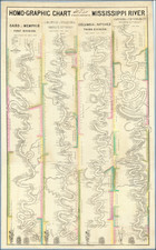
Norman' is perhaps best known for his "Chart of the Lower Mississippi River", designed by Marie-Adrien Persac.
Rarity
We note only two recorded examples of the 1845 edition of the map, one in the Library of Congress and the other at Yale.