


|
||

|

|
|

|
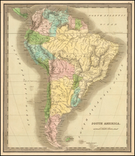
Rare additional map issued by Vandermaelen, showing how his atlas volumes of North America and South America could be joined to form a single map.
The map shows Upper California and Texas as part of Mexico, a massive Oregon Territory and a excellent treatment of the River Systems of the Western US, following Lewis & Clark and Pike's Expeditions.
Vandermaelen's work was a cartographic landmark, being the first atlas of the world to be produced on a uniform scale. In fact, the various sheets were constructed in order to allow for the sheets to be joined to form a massive globe. The work was a tremendous success and a number of the map sheets were modified one or more times during the publication of the atlas, which comprised 6 volumes (North America, South America, Africa, Europe, Asia and Oceana.
Vandermaelen's atlases each included a key sheet, but in later editions, this special map was issued to show how the sheets from different volumes could be joined.
Philippe Marie Vandermaelen (1795-1869) was a Belgian cartographer and geographer known for his pioneering use of technology and his leadership in establishing the important Establissement geographique de Bruxelles. Born in Brussels, Philippe was obsessed with maps from a young age. He taught himself mathematics, astronomy, and mapmaking and plotted the battles of the Napoleonic wars avidly. He took over his father’s soapmaking business briefly in 1816, but then turned it over to his brother in favor of cartography.
From 1825 to 1827, he released his first atlas, the Atlas universal, which was well received. It was sold in forty installments of ten maps each, with 810 subscribers listed. The atlas contained 387 maps in six volumes at a uniform scale of 1:1.6 million. The maps were intended to be joined and together would create a globe 7.755 meters wide. It was the first atlas to show the entire world on a large uniform scale and was the first atlas produced using lithography. This project served as Vandermaelen’s gateway into intellectual life, gaining him membership in the Royal Academy of Sciences and Belles-Lettres of Brussels (1829).
In 1830, Vandermaelen inherited a laundry from his parents which he converted into the Establissement geographique de Bruxelles, or the Brussels Geographical Establishment. His brother, Jean-Francois, also established a botanical garden on the site. The Establishment had its own lithographic press, one of the first to use the technology for cartography and the first in Belgium. They produced textbooks, surveys, and especially maps of Brussels to be used for urban planning. The complex also housed schools, an ethnographic museum, and a library open to the public. Vandermaelen was passionate about geographic education and saw the Establishment as an open place where people could learn about the world.
In 1836, he was knighted for his services to geography and the intellectual community of Belgium. He died at age 73 in Molenbeek-Saint-Jean, near the Geographical Establishment that he founded. After Vandermaelen’s death, the Geographical Establishment declined, closing its doors in 1880. The extraordinary collection they had amassed passed to several institutions, most importantly the Royal Library of Belgium.
![(Mexican-Aztec Painting) [Watercolor of four Aztec deities from the Codex Telleriano Remensis and Codex Vaticanus]](https://storage.googleapis.com/raremaps/img/small/103011.jpg)
![[French & Indian War] Carte Des Possessions Francoises et Angloises dans le Canada et Partie de la Louisiane . . . 1756](https://storage.googleapis.com/raremaps/img/small/94026.jpg)