|
||

|

|
|

|
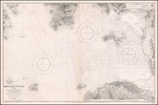
An Exceptional Post-World War II Chart of Hong Kong and Environs -- The First British survey of Hong Kong Harbor, updated to 1952
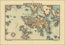
Remarkably detailed British Admiralty Sea Chart of Hong Kong, first published in 1843, based upon the surveys of Sir Edward Belcher.
This example includes a large note in red manuscript stating "NOT TO BE USED FOR NAVIGATION." Annotations in the area of Lamtung and other parts of the east side of the chart suggest that it was probalbly annotated by an official source, for use in the next set of small updates, a suggestion confirmed by the purple notes in the lower left "Small Corrections" area, which appears in the same hand as the purple annotations in the chart.
An area off Tsing Islands is referenced as "Dupming Ground (Explosives)." The area between Siu Kau Island and Kaui Chau Island is shown as "Dumping Ground (Salvages)."
Belcher's survey was the first large format map or sea chart of Hong Kong. On January 26, 1841, Edward Belcher and his men were the first of the British fleet to land on Possession Point at the north shore of Hong Kong for the British Crown. He subsequently made the first British survey of Hong Kong harbor. While the map is dated 1841, the first edition of the map was not published until May 1843.
Over the next century, the chart was regularly revised and improved, most notably with contributions from three later surveys conducted by Commander A.M. Field in 1891, Commander W.U. Moore in 1892-93, Captain M.H. Smyth in 1901-02, Commander C.E. Monro in 1905 and by the Hong Kong Harbour Department and Admiralty thereafter.
The character and detail of Hong Kong and the contiguous part of Kaulung have evolved considerably.
The chart presents a remarkable image of Hong Kong on the eve of World War II, reflecting its remarkable transformation over the prior century.
The British Admiralty has produced nautical charts since 1795 under the auspices of the United Kingdom Hydrographic Office (HO). Its main task was to provide the Royal Navy with navigational products and service, but since 1821 it has also sold charts to the public.
In 1795, King George III appointed Alexander Dalrymple, a pedantic geographer, to consolidate, catalogue, and improve the Royal Navy’s charts. He produced the first chart as the Hydrographer to the Admiralty in 1802. Dalrymple, known for his sticky personality, served until his death in 1808, when he was succeeded by Captain Thomas Hurd. The HO has been run by naval officers ever since.
Hurd professionalized the office and increased its efficiency. He was succeeded by the Arctic explorer Captain William Parry in 1823. By 1825, the HO was offering over seven hundred charts and views for sale. Under Parry, the HO also began to participate in exploratory expeditions. The first was a joint French-Spanish-British trip to the South Atlantic, a voyage organized in part by the Royal Society of London.
In 1829, Rear-Admiral Sir Francis Beaufort was appointed Hydrographer Royal. Under his management, the HO introduced the wind force scale named for him, as well as began issuing official tide tables (1833). It was under Beaufort that HMS Beagle completed several surveying missions, including its most famous voyage commanded by Captain FitzRoy with Charles Darwin onboard. When Beaufort retired in 1855, the HO had nearly two thousand charts in its catalog.
Later in the nineteenth century, the HO supported the Challenger expedition, which is credited with helping to found the discipline of oceanography. The HO participated in the International Meridian Conference which decided on the Greenwich Meridian as the Prime Meridian. Regulation and standardization of oceanic and navigational measures continued into the twentieth century, with the HO participating at the first International Hydrographic Organization meeting in 1921.
During World War II, the HO chart making facility moved to Taunton, the first purpose-built building it ever inhabited. In 1953, the first purpose-built survey ship went to sea, the HMS Vidal. Today, there is an entire class of survey vessels that make up the Royal Navy’s Hydrographic Squadron. The HO began to computerize their charts in the late 1960s and early 1970s. In 1968, the compilation staff also came to Taunton, and the HO continues to work from there today.
![[Hong Kong, Macao, Canton, etc] A Chart of the China Sea from the Island of Sanciam To Pedra Branca with the Course of the River Tigris From Canton to Macao Corrected From the Surveys Made By Capn. Jos. Huddart and Captn J.P. Larkins . . . 1794](https://storage.googleapis.com/raremaps/img/small/85334.jpg)
![[ Hong Kong / Canton ] Nieuwe Pas=Caart Strekkende van Pta Cataon tot Pta Lamtaon langs de kusten von Cochinchina, Tonquin, Quangsi en Quantung bewattende insgelyks het eiland Aynam en die van Macao met dieptens, havens en ankergronden . . .](https://storage.googleapis.com/raremaps/img/small/66695.jpg)