
This item has been sold, but you can enter your email address to be notified if another example becomes available.


|
||

|

|
|

|
Stock# 55600
Description
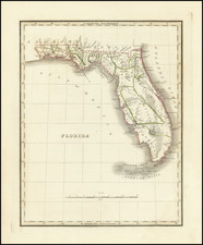
Scarce of this early map of Florida, bearing the imprint of Edward Stanford, but still naming St. Lucie County, which pre-dated the name change to Brevard County in 1855.
Excellent early map of Florida, being one of the earliest obtainable separate maps of Florida to appear in a commercial atlas. Shows early counties, towns, roads, INDIAN PATHS, Indian Villages, court houses, lakes, rivers, bays, keys, forts, etc. Inset of panhandle.
One of the best early maps of Florida and certainly one of the most detailed.
The map was apparently taken from American sources, including HS Tanner. The Society for the Diffusion of Useful Knowledge was active from the 1830s through the 1860s and published some of the best regional maps of the era.
![[War of Jenkins Ear in Florida and West Indies] [Harbors, Towns & Fortresses of North America, St. Augustine, Providence (Grand Bahama Island), Porto Antonio (Jamaica), Havana, Santiago (Cuba), Kingston, and Antiqua)]](https://storage.googleapis.com/raremaps/img/small/75642.jpg)
![[Florida and Gulf Coast] The Coast of West Florida and Louisiana . . . [with] The Peninsula and Gulf of Florida or Channel of Bahama with the Bahama Islands . . .](https://storage.googleapis.com/raremaps/img/small/66344.jpg)
![(Tallahassee, Florida / Signed by John Quincy Adams) [Certification of full payment by John Boyd for 79 acres of land in Tallahassee, acquired from the General Land Office]](https://storage.googleapis.com/raremaps/img/small/86625.jpg)

