|
||

|

|
|

|
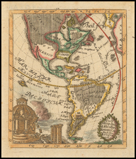
Striking, Ornate Eighteenth-Century Wall Map of the Americas
Nolin’s dramatic, decorative wall map of the Americas, a format that was rare by the mid-eighteenth century. This example includes the impressive border with its historical vignettes.
The four-sheet map shows North America to the 60th parallel and all of South America. On a curved projection, parts of Europe and Africa are tucked into the north and east of the map. Tucked into the northwest are huge Terres Inconnues, or unknown lands, which are noted as connecting to the search for Gamaland and the supposed sighting of Compagnies Land by the Dutch in the mid-seventeenth century. Farther southeast are the Indes Meridionales, or the South Indies, which are based on the dubious reports of de Gonneville by the Abbé Paulmier.
Nearby, on the American side of a strait reported as extant by Indigenous peoples, a note mentions a Chinese coast. This note stems from the work of French Orientalist Le Guignes, who hypothesized that the Chinese arrived in the New World over a millennium before the Europeans in his writings. Le Guignes was named a fellow of the Royal Society of London in 1752 and his work was well known across Enlightenment Europe.
While the strait between Asia and America suggests a vague Northwest Passage, the delineation of the Great Lakes is more definitive. The Mississippi River is also well defined.
South America stretches toward Tierra del Fuego. Nearby are the Isles Nouvelles or new islands, which are also labeled as Is. Sebald. This is an amalgamation of two separate discoveries that were likely both actually sightings of the Falklands, or the Malvinas as the Spanish call them. The Sebalds or Sebaldines were charted by Sebald de Weert, a Dutchman, as he fled from the treacherous Straits of Magellan at the turn of the seventeenth century. Nearly a century later, in 1690, John Strong sailed amongst nearby (or the same) islands and called them the Falklands.
In the northern Atlantic is a tiny island, I. Brazel. Also known as Hy Brasil, the island is an enduring Atlantic chimera that came from Celtic folklore. It ranges on maps from just off the west coast of Ireland to the area around the Azores. The island was initially described as a rich paradise not unlike Atlantis; it emerged from the depths for a short period and then would disappear. It started to appear on portolan charts in the fourteenth century and continued to be a stalwart of maps and charts into the nineteenth century. The island was the subject of a fanciful pamphlet by Richard Head in 1675. Despite no accurate reports of its whereabouts, the island appeared on Admiralty charts and other reputable maps for centuries, usually in the latitude of 51°N and at a longitude of 17°W.
The decorative elements of the map are particularly pronounced. On the face of the map, there are many sea monsters and ships. The largest of these vessels are engaged in a pitched battle in the Pacific. The title is encased in an ornate cartouche that shows vignettes of missionaries bringing the word of God to the fertile land of the Americas. The beaver vignette, made famous on maps by de Fer, Moll, and Chatelain, is also included here.
In the lower left corner, the scale bars are tucked into a tableau of Indigenous peoples engaged in cannibalism, while white settlers aim weapons at them. This concern with cannibalism was typical of European preoccupations as they expanded their empires into Indigenous lands across the world, but especially in the Americas.
The most eye-catching element of the map is the decorative border, which attaches separately from the sheets of the map. The border would have been sold separately and is not included on all surviving examples of the wall map. The border includes expansive historical and geographical descriptions of the continents at the bottom. The historical theme is continued in the thirty scenes that follow, which show early work by missionaries, the invasion of Mexico and Peru by conquistadores, and acts of possession such as Magellan’s navigation of the straits that would be named for him (complete with giants!). Some of the vignettes even show pre-Colombian history, such as the establishment of the Incan and Aztec Empires.
The map is a magnificent and luxurious survival, one of the last wall maps of its kind, as they were out of vogue by the mid-eighteenth century. The map was first released by the younger Jean-Baptiste Nolin as early as 1720 and in a finished state in 1740. Nolin ran into financial problems in the late 1740s and sold some of his plates to Jean Baptiste Crepy (fl. 1753-1796), who re-printed the map in 1755, 1775, 1783, 1784, and 1785. It would seem that Crepy added the decorative border when he began to sell the map. He updated the dates of publication and, after 1774, changed the dedication from Louis XV to Louis XVI. It is clear the map proved popular and Crepy turned to it when the Americas were of particular interest, such as at the outbreak of the Seven Years’ War and during the American Revolution.
Following the routes of explorers and navigators
Sea monsters and ships are not the only features in the seas here. There are also the tracks of several famous explorers. In the Atlantic, the three voyages of Christopher Columbus in the 1490s are shown, as well as the typical routes to and from New Orleans and Saint Domingue, important French holdings, for European ships.
Crossing the ocean and skirting Newfoundland is the, “Route de Jean Varrazan par ordre de Francois Premier en 1524.” This is Giovanni de Verrazzano, a Florentine in the employ of the French Crown who claimed North American territory for France in 1524.
In the Pacific, Magellan’s route is included. He led the first circumnavigation of the world (1519-1522), although he did not complete the circuit, having died in the Philippines. Other ships soon followed his lead through the Straits of Magellan and into the South Seas.
Both routes taken by Mendaña and that of his pilot, Quiros, are seen here. Álvaro de Mendaña led a Spanish expedition to the Solomon Islands in 1567-9, but his crew forced his return to Peru. Another attempt was made from 1595-6 to return to the Solomons, but they had not been charted accurately. Mendaña died on Santa Cruz, leaving his wife in charge of the settlement they had started. She decided to return to Spanish dominions and they arrived in the Philippines in early 1596.
Pedro Fernandez de Quiros accompanied Mendaña on his second voyage. After returning to Spain, he convinced authorities that he could find Terra Australis, the southern continent, if they gave him ships and supplies. He set out in 1605 and eventually landed in Vanuatu. He mistook one of the islands for the fabled continent and called it Austrialia de Espiritu Santo. Quiros intended to set up a colony, but his crew forced him to leave.
Finally, going from Atlantic to Pacific, but not via the Straits of Magellan, is the track of Schouten and Le Maire. Jacob Le Maire and Willem Schouten led a circumnavigation that intended to break the monopoly over navigation via the Straits of Magellan held by the Dutch East India Company (VOC). They skirted the coast of Tierra del Fuego and found a strait between that network of islands and Staten Land, an island. This new way into the Pacific Ocean was lauded as a major coup for exploration and gained the voyage enduring fame.
Unknown polar lands
In the far north and south of this map are large continent-like landmasses that connect to enduring geographic chimeras of the early modern period. In the north are the unknown lands which allude to Gamaland and Compagnies Land. Juan de Gama, the grandson of Vasco de Gama, was a Portuguese navigator who was accused of illegal trading with the Spanish in the East Indies. Gama fled and sailed from Macau to Japan in the later sixteenth century. He then struck out east, across the Pacific, and supposedly saw lands in the North Pacific. These lands were initially shown as small islands on Portuguese charts, but ballooned into a continent-sized landmass in later representations.
Several voyagers sought out these chimerical islands, including the Dutchmen Matthijs Hendrickszoon Quast in 1639 and Maarten Gerritszoon Vries in 1643. Compagnies Land, often shown along with Staten Land, were islands sighted by Vries on his 1643 voyage. He named the islands for the Dutch States General (Staten Land) and for the Dutch East India Company (VOC) (Compagnies, or Company’s Land). In reality, he had re-discovered two of the Kuril Islands. However, other mapmakers latched onto Compagnies Land in particular, enlarging and merging it with Yesso (Hokkaido) and/or Gamaland.
Vitus Bering, a Danish explorer in Russian employ, and later James Cook would both check the area and find nothing. La Perouse also sought the huge islands, but found only the Kurils, putting to rest the myth of the continent-sized dream lands.
In the Antarctic are lands seen by de Gonneville. This is a reference to the alleged discoveries of Binot Paulmier, Sieur de Gonneville. This French captain supposedly sighted and landed on fertile soil south of the Cape of Good Hope in the early sixteenth century.
With two Portuguese pilots and a crew, de Gonneville sailed from Honfleur in Normandy. His destination was the East Indies. When he reached the Cape of Good Hope, however, his ship, L'Espoir, was blown to an unknown shore. By 1505, he had returned to Europe, claiming to have discovered Terra Australis Incognita. De Gonneville said that his crew had stayed for six months in this new land, where the local people did not have to labor due to the fertility and bounty of the earth.
These reports were not widely known, however, until the seventeenth century. The Abbé de Paulmier hatched a plan to convert the citizens of the Southern Continent. To bolster his request for an expedition, Paulmier produced a pamphlet outlining the known geography of the area. To argue that Terra Australis does indeed exist, the Abbé cited the account of de Gonneville, which also explained that, when the navigator returned to Normandy, he brought with him Essonier, the prince of the land he had visited. Essonier settled in Normandy and married de Gonneville’s daughter. Paulmier claimed to be a descendent of this union, hence his interest in the venture.
If corroborated, de Gonneville’s landing south of the Cape of Good Hope would claim Terra Australis for France by right of first discovery. The problem was, there was no prior mention of de Gonneville before the Abbé’s petition (1654) and pamphlet (1664). Nevertheless, Gonneville’s “discoveries” in the south Indian Ocean began to be incorporated into maps from as early as 1661. Until James Cook’s second expedition in the late-eighteenth century, French efforts at South Seas discovery would continue to focus on the elusive de Gonneville’s Land.
Jean-Baptiste Nolin (ca. 1657-1708) was a French engraver who worked at the turn of the eighteenth century. Initially trained by Francois de Poilly, his artistic skills caught the eye of Vincenzo Coronelli when the latter was working in France. Coronelli encouraged the young Nolin to engrave his own maps, which he began to do.
Whereas Nolin was a skilled engraver, he was not an original geographer. He also had a flair for business, adopting monikers like the Geographer to the Duke of Orelans and Engerver to King XIV. He, like many of his contemporaries, borrowed liberally from existing maps. In Nolin’s case, he depended especially on the works of Coronelli and Jean-Nicholas de Tralage, the Sieur de Tillemon. This practice eventually caught Nolin in one of the largest geography scandals of the eighteenth century.
In 1700, Nolin published a large world map which was seen by Claude Delisle, father of the premier mapmaker of his age, Guillaume Delisle. Claude recognized Nolin’s map as being based in part on his son’s work. Guillaume had been working on a manuscript globe for Louis Boucherat, the chancellor of France, with exclusive information about the shape of California and the mouth of the Mississippi River. This information was printed on Nolin’s map. The court ruled in the Delisles’ favor after six years. Nolin had to stop producing that map, but he continued to make others.
Calling Nolin a plagiarist is unfair, as he was engaged in a practice that practically every geographer adopted at the time. Sources were few and copyright laws weak or nonexistent. Nolin’s maps are engraved with considerable skill and are aesthetically engaging.
Nolin’s son, also Jean-Baptiste (1686-1762), continued his father’s business.

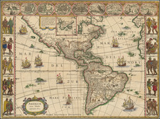
![[ First State of the First Map of America ] Novae Insulae XVII Nova Tabula](https://storage.googleapis.com/raremaps/img/small/94609.jpg)