
This item has been sold, but you can enter your email address to be notified if another example becomes available.


|
||

|

|
|

|
Stock# 55516
Description
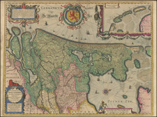
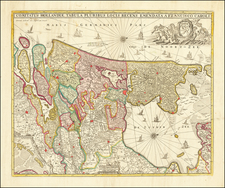
Detailed map of OverIjssel, published at the end of the 17th Century by Mortier.
The map credits Sanson as the source of the material, but in fact the map is drawn from the work of A.H. Jaillot, circa 1672.
Larger towns include Campen, Zwol, Covorden, Deventer, Zutphen, Enschede.
Pierre Mortier Biography
Pierre, or Pieter, Mortier (1661-1711) was a Dutch engraver, son of a French refugee. He was born in Leiden. In 1690 he was granted a privilege to publish French maps in Dutch lands. In 1693 he released the first and accompanying volume of the Neptune Francois. The third followed in 1700. His son, Cornelis (1699-1783), would partner with Johannes Covens I, creating one of the most important map publishing companies of the eighteenth century.
![[ Holy Roman Empire ] Nova Totius Germaniae Descriptio Geographica](https://storage.googleapis.com/raremaps/img/small/95672.jpg)