|
||

|

|
|

|
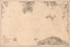
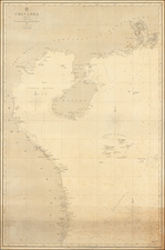
Rare Working Survey Chart Created In Hong Kong Aboard the HMS Challenger During Surveys To Improve Existing Charts of Hong Kong Harbor
Detailed sea chart of Hong Kong with manuscript additions, created by the Hong Kong Surveying Unit in November and December of 1945.
The chart appears to be a contemporary copy of the resurvey work done by the H.M.S. Challenger, immediately following the conclusion of World War II. It would appear that the present chart reflects the ongoing surveys then being undertaken by the Challenger and transmitted back to London, in order to revise Chart No. 3280.
The chart includes the following note:
Tracing of Chart No. 3280 showing resurvey carried out with soundings obtained, wrecks and obstructions fixed, Amended coastline and topography is shown in Red. The area including Cosmopolitan Dock has been resurveyed on a scce of 1/6080 and is shown in inset.
Mooring buoys are being raised and relaid and a subsequent tracing will be forwarded with this information when completed together with particulars of anchorages, bethres and salvaged wrecks.
The chart bears the following inscriptions at the top and a facsimile signature:
To accompany Challenger's letter 111/4185 of 28th December 1945
Approved.
C. Sabine
Commander in Chart of Survey
At the end of World War II, the job of improving the existing charts of Hong Kong Harbor fell to a specially commissioned part of the British Admiralty called the Hong Kong Surveying Unit. As noted by Tam Kowng-lim in Making Charts for and around Hong Kong -- Survey Work Since the Second World War":
Since the Second World War, the British returned to East Asia. Since 1941, under pressure from Japanese naval expansion in Asia, the British China Station was re-organized, with the stipulation that in the event of war, the three main commands in the Far East, the East Indies Squadron, the China Squadron and the Australian Squadron, should all fall under one command called the Eastern Fleet based in Singapore. When the Allied forces gained the upper hand and Japanese expansion was checked, the British created the British Pacific fleet in 1944 - 1945, and the Eastern Fleet later became the Far East fleet which operated in all Far East areas, including parts of the Pacific Ocean.
Similar to the arrangement of the “China Station”, the main bases remained in Singapore and Hong Kong, where the survey vessels were based.
Partly because of reduced funding and perhaps due to post-war geopolitical realities, British naval survey ships’ work in Hong Kong waters was gradually curtailed. Survey vessels stationed in the Far East were often more focused on survey work in Malaysian waters. Often only one survey ship was assigned to the Far East Fleet, covering the survey work of Southeast Asia and occasionally Hong Kong.
In 1945, to urgently upgrade and update the pre-war Admiralty charts, a special Hong Kong Surveying Unit was set up and tasked with obtaining local sounding data. A survey ship, HMS Challenger (commissioned in 1932, of 1,140 long ton displacement and a shallow draft of 3.81 metres), was sent to assist the Hong Kong Surveying Unit in surveying and producing two charts: “Hong Kong Water, East” and “Taikoo Docks and Aldrich Bay”. The dock area was heavily bombed during the War and therefore needed re-surveying.
The present chart, "Hong Kong Waters West", was apparently unknown to the author.
An important post World War II survey chart, which was almost certainly used to improve Chart 3280, however, we locate no surveying examples of this chart.
![[Hong Kong / Disneyland] Ngon Shun Chau (or Stonecutters Island) to Brothers Pt.](https://storage.googleapis.com/raremaps/img/small/55579.jpg)