


|
||

|

|
|

|
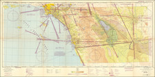
Detailed aeronautical map of Southern California, extending from Catalina and the Channel Islands and Los Angeles to the Arizona Border and to just south of San Diego and the Mexican Border.
The chart is a font of information about civil and military aviation in postwar Southern California. It was intended for civil aviators flying by visual navigation and so includes data that would be useful for this purpose. Topographical information consists of relief and a judicious selection of visual checkpoints used for navigation under visual flight rules. The checkpoints include populated places, roads, and distinct landmarks. The aeronautical information includes visual and radio aids to navigation, airports (aerodromes, both for landplanes and seaplanes), controlled airspace, restricted areas, and obstructions. Sectional Aeronautical Charts were updated somewhat frequently at this time and are now produced by the FAA.
Similar charts were prepared for other sections of the country and this one could have been joined with charts of the regions associated with San Francisco, Los Angeles, Prescott, Phoenix, and Douglas, to created a larger image.
On the Lambert Conformal Conic Projection.
A fascinating chart--the first we have seen on the market.