


|
||

|

|
|

|
Including The First Map of Georgia and an one of the Most Important Maps of the Mississippi River and Great Lakes
Recueil de Voiages au Nord Contenant divers Mémoires très utiles au Commerce and à la Navigation. Tome neuviéme. La Carte de la Georgie et la Carte du Voiage du Pere Hennepin.
J.F. Bernard, Amsterdam: 1737. 12mo. Old Calf. pp. 596. 2 maps.
The volume includes two important maps and the following sections
- I. Raisons qui ont porté le gouvernement de la Grande Bretagne à former l'etablissement d'une Colonie dans la Georgie traduit de l'Anglois du Chevalier Benjamin Martin.
- II. Relation des Natchez contenue dans une Lettre du P. Le Petit, Missionaire de la Compagnie de Jesus.
- III. Decouverte d'un Pays plus grand que l'Europe, situe, dans l'Amerique entre le Nouveau Mexique and la Mer glaciale par L. Hennepin.
J.F. Bernard's Volume 9 includes two works with maps of seminal importance to the history of North America:
- An early translation of Benjamin Martin's 1733 Reasons for Establishing the Colony of Georgia
- Hennepin
Benjamin Martin's Map of Georgia and Reasons for Establishing the Colony of Georgia
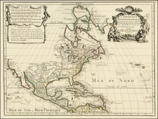
The first work includes an early enlarged copy of Benjamin Martin's map of the Georgia, the first separate map of the Georgia Colony, originally published in England in 1733.
It is a somewhat larger example that was apparently taken from the 1733 map in Martyn's Reasons for Establishing The Colony of Georgia, although with numerous errors and omissions. This map has also been attributed to James Oglethorpe, founder of the British Georgia colony in 1732, and presents extensive English claims southward to just north of St. Augustine, no doubt inflaming Spanish interests at the time. This hostility led to the War of Jenkins Ear in 1739.
The map covers the region from Florida and up the east coast extending north to above the Cartuck River at the northern border of South Carolina. It extends west to beyond the Mississippi River, showing all of colonial South Carolina, Georgia and Florida. The southern portion of Florida is composed of numerous islands. A southerly coast along the Florida panhandle suggests vast lands that could be utilized by farmers under the Oglethorpe Plan for colonization. Coincidentally, the lands end at the line demarcating The South Bounds of Carolina .Charles Town, Port Royall, St. Augustine and a few other settlements are noted.
The prime meridian is drawn at Charleston. This map also includes notations related to the number of men in various Indian tribes: Illinois 500 men, Weachthenoes 500 men, Okesee Nation 700 men.
The text is a French translation of the second and enlarged edition of Martin's tract, with letters of General Oglethorpe with "resolutions of the Assembly relative to his arrival" not present in the first edition of the same year. "A well-written tract; plausible in its arguments, glowing in its descriptions, valuable for its information, and pertinent in its appeals to the philanthropic and benevolent" (Sabin).
Martyn was the secretary to the Society for Establishing the Colony of Georgia, and this is his second work promoting the colony:
Louis Hennepin Map and Decouverte
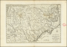
The second work of importance is Bernard's edition of Louis Hennepin's Nouvelle decouverte d'un tres grand pays situe dans l'Amerique, entre le Nouveau Mexique, et la mer Glaciale, first published in 1697.
The tract provides an account of Hennepin's travels in America and includes one of the most important and influential maps of the Mississippi River and Great Lakes.
This extraordinary map was one the earliest and most important depictions of the Great Lakes, Mississippi Valley and Ohio Valley, a marked improvement over earlier maps. However, the Great Lakes are still considerably ovesized, Hudson Bay too far to the east and the Mississippi River too far to the west, with its mouth in what is present-day Texas, based upon La Salle's report.
Fr. Louis Hennepin, a member of the Recollect Order of Franciscans, accompanied Rene-Robert de LaSalle on part of his journey down the Mississippi in 1682. LaSalle was hoping to reach the Pacific Ocean, but instead ended up in the Gulf of Mexico, thereby adding a large slice of North America to French claims west of the Appalachians, well away from the threat of British colonists.
An excellent summary of the state of knowledge of North America, at the beginning of the 18th century. Among other things, this beautiful map attempts to place into perspective Hennepin's mapping of the Great Lakes and the Mississippi River. Karpinski noted that Hennepin's delineations of Lakes Superior, Michigan and Huron are remarkable improvements upon the Sanson maps.
Hennepin was one of the most popular chroniclers of the exploration of the American interior. Several books in numerous editions appeared under his name, although he was also given to sensational and unsupportable claims, such as his claim to have been first to the mouth of the Missisippi, ahead of LaSalle.
Rarity
Bernard's Recueil de Voiages au Nord was issued in multiple volumes beginning in 1715 and typically does not appear on the market as a complete set. Volume 9 as a separate volume is rare on the market.
![[ New France - Pierre Biard's Letter ] Missio Canadensis [in] Annuæ Litteræ Societatis Jesu Anni MDC.XI.](https://storage.googleapis.com/raremaps/img/small/84352.jpg)

