|
||

|

|
|

|
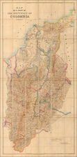
Bogota as the Prime Meridian!
Rare large format map of most of Colombia (omitting a small portion of the west coast, to the west of the Rio Quito, bearing the signature of William Lidstone, C.E.
The map contains political division with added color, indicates the existing railroads with red lines and those under construction with a line of red dashed lines.
The present map would appear to be the first edition of the map, issued in June, 1899, with a facsimile signature. A second edition was issued in 1903, with the title modified to add the words "By William Lidstone, C.E."
William Lidstone was an English civil engineer and artist born in Kingsbridge, Devon in 1843, died in Bogotá, Colombia, in 1927. Co- author of Fifteen thousand miles on the Amazon and its tributaries by C.B. Brown and W. Lidstone and Charles Barrington (1878). The map was referred to in one publication as “the most reliable map of that region” (The Emerald Deposits of Muzo, Colombia, By Joseph E. Pogue,, Ph. D., Evanston, Illinois. Transactions of the American Institute of Mining Engineers. Vol. LV, 1917 .Arizona Meeting, September, 1916. )
The Geographical Journal, Vol 21, No 3,(March 1903) includes the following entry describing the map:
The title of this map is decidedly vague and indefinite, but the "part' of the Republic of Colombia it refers to as shown on the map, includes the departments of Bolivar, Magdelena, Santander, Antioquin, Tolima, the western part of Boyaca and Cundinamarca, and the eastern half of Cauca. The map thus represents all the central and most important region of Colombia, including the capital and the courses of the rivers Magdelena and Cauca.
The geographical features of this country are still very imperfectly known, and, with the exception of the route-surveys of mining engineers and a few others, little additional information is to be obtained that is not given on Cedazzi's large atlas which was published over sixty years ago. Any addition to our knowledge is therefore specially welcome. Mr. Lidstone, the author of this map, in the pursuit of his profession as a civil engineer, has travelled extensively in the country, and from his route-surveys, combined with other information, this map has been compiled. In many districts, however, the map is not nearly so complete as it might have been if the surveys of others had been properly utilized. An instance of this is to be found in the northern part, where Mr. F. A. A. Simons has worked for years, but the results of whose surveys seem to have been almost entirely ignored. Had the information contained on his maps of the departments of Bolivar and Magdelena and of the river Sinci been made use of, Mr. Lidstone could have rendered his map far more complete. The map is printed in colours, and shows railways existing and in course of construction.
Rarity
The map is very rare. OCLC locates 3 examples (SMU, University College, Cork, and the Institute for Historical Research (UK)).
We locate no other examples on the market or at auction in any standard reference work.
Edward Stanford (1827-1904) was a prominent British mapmaker and publisher. A native of Holborn in the heart of London, Edward was apprenticed to a printer and stationer at the age of 14. After his first master died, he worked with several others, including Trelawny W. Saunders of Charing Cross. Saunders oversaw young Edward’s early career, ensuring that he became a Fellow of the Royal Geographical Society. Associations with the Society eventually brought Sanders much business and gave him a reputation as a publisher of explorers. As testament to this reputation, the Stanford Range in British Columbia was named for him by John Palliser.
Stanford briefly partnered with Saunders in 1852 before striking out on his own in 1853. He was an agent for the Ordnance Survey, the Admiralty, the Geological Survey, the Trigonometrical Survey of India, and the India Office. He also controlled the maps of the Society for the Diffusion of Useful Knowledge, another lucrative source of income. In 1857, Stanford founded his namesake Geographical Establishment, with Saunders and A. K. Johnston as engravers. Thereafter, Stanford was known for his “library maps”, particularly those of Africa and Asia.
Addresses and Years of Operation:
- 6 Charing Cross, London (1848): Edward Stanford's initial place of employment at Trelawney Saunders' shop.
- 7 and 8 Charing Cross, London (1853): Stanford expanded his shop to these addresses.
- 55 Charing Cross, London (1873): The shop moved to this larger location.
- 12-14 Long Acre, London (1873): Site of the new print works and current flagship store.
- 7 Mercer Walk, London (2019): Stanfords moved to this address, continuing its legacy.
Stanford's work with Chief Cartographer John Bolton, including the 1858 Library Map of Europe, positioned the company as a leader in quality cartography during a time of exploration and colonialism. Their 1862 Library Map of London earned acclaim from the Royal Geographical Society. With the business thriving, Stanford purchased Staunton & Son in 1877 and, upon retiring in 1885, handed over the reins to his son, Edward Stanford II.
As sole agents for Ordnance Survey Maps, the company's influence and reputation grew, culminating in the Stanford’s London Atlas Of Universal Geography, which was presented to Queen Victoria in 1887. The transition into the 20th century saw further integration of retail, print, and cartographic operations at Long Acre.
During World War I, Stanford's became an essential publisher for the War Office. Edward Fraser Stanford took over in 1917, steering the company through the interwar period and innovations, such as the world’s smallest maps in 1922 and the Daily Mail Motor Road Map in 1926.
Withstanding a bombing in WWII, the company continued under the stewardship of John Keith Stanford and was sold to George Philip & Son in 1947. As it adapted to the digital age, Stanfords received the Ordnance Survey Premier Partner status in 2007 and ventured into online mapping and data services.
Stanfords, now an icon for travellers and explorers, has maintained its cultural relevance and retail success well into the 21st century, underpinned by a legacy of entrepreneurial spirit and commitment to cartographic excellence.
![[ Manuscript Map of Province of Quito ] Carta de la Provincia de Quito i de sus adyacentes, obra postuma de Don Pedro Maldonado . . . Paris MDCCL](https://storage.googleapis.com/raremaps/img/small/98908op.jpg)
![(Colombia and Panama) Quarta Hoja que Comprehende las Costas de la Provincia de Cartagena, Golfo Del Darien y Provincio de Porto Velo con el Golfo de Panama y Archipelago de las Perlas. Madrid Año 1817. [Fourth Sheet that Covers the Coasts of the Province of Cartagena, Gulf of Darien and Province of Porto Bello with the Gulf of Panama and Archipelago of the Pearls. Madrid, Year 1817.]](https://storage.googleapis.com/raremaps/img/small/95581.jpg)