|
||

|

|
|

|
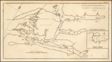
Rare 1869 map of New Zealand’s North Island showing Māori iwi (tribal) boundaries, confiscated land, location of armed police and military bases, and where gold was found.
The map illustrates the more than 1.2 Million acres of land confiscated in the Waikato. The confiscations were made under the New Zealand Settlements Act 1863.
The map illustrates:
- Tribal Boundaries and Names
- Bush Land
- Land Confiscated
- Stations of Armed Constabulary
- Gold Fields located and possible mines
The confiscated lands are divided into 5 groups
- Waikato
- Tauranga
- Bay of Plenty
- Hawkes Bay Province
- Taranaki & Wellington Provinces
From a Museum of New Zealand: Te Papa Tongarewa entry on Māori land rights:
The Crown created various laws in the 1860s to allow it to take land. The New Zealand Settlements Act 1863 allowed it to confiscate the land of North Island iwi deemed to have rebelled against the Crown. The Public Works Act 1864 let it take land for roads, railways, and other public works.
The Native Land Court, established in 1865 (and renamed the Māori Land Court in 1954), encouraged Māori to sell land to private buyers. But the Crown remained the biggest purchaser. It on-sold most of its Māori land, often for a profit.
By 1939, almost 100 years after the Treaty was signed, Māori retained just 1 percent of the South Island and 9 percent of the North Island. Land losses continued as the 20th century progressed, again supported by legislation.
Rarity
The map is very rare on the market. This is the first example we have ever seen offered for sale.
![Isles de Salomon [Early depiction of New Zealand!]](https://storage.googleapis.com/raremaps/img/small/101683.jpg)
![[ Promoting the Products and Industries of New Zealand ] New Zealand -- Compiled by The New Zealand Map Co.](https://storage.googleapis.com/raremaps/img/small/102104.jpg)
![Neu-Seeland [with] West Australien [with] Tasmania](https://storage.googleapis.com/raremaps/img/small/98073.jpg)