This item has been sold, but you can enter your email address to be notified if another example becomes available.


|
||

|

|
|

|
Stock# 55330
Description
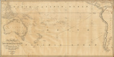
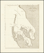
Rare map of eastern Australia and Northern New Zealand, which appeared in the Hydrographical Atlas to accomany the Voyage au Pole sud et dans l'Ocʹeanie exʹecutʹe par ordre du roi sur le Corvettes L'Astrolabe et la Zʹelʹee pendant les annʹees 1837-1838-1839-1840 sous le commandement de M.J. Dumont-D'Urville . . .
The chart covers New South Wales in fine detail, from Mt. Kosciusko and Mt. Dromedary to Mt. Dryander and Repulse Bay in the north, with some river and topographical detail in the interor.
A highly detailed chart from an important early French expedition.
Condition Description
Minor soiling.